Trekup India
Upcoming Treks
Trek Gears Tips & ReviewsTrek GuideSave The TrailTrekkers Corner and SpaceTrekup India on Trek ProtocolTrekking and HealthSeason Wise Trek GuideTrekking TipsTravel Tips & Guides
Customize TrekSchool/College ProgramsBoardroom to Basecamp
All Trekpedia TreksTreks in UttarakhandTreks in Himachal PradeshTreks in Jammu & KashmirTreks in NepalTreks in SikkimTreks in Karnataka
Trekup India
Explore
Upcoming Treks
Trek Gears Tips & ReviewsTrek GuideSave The TrailTrekkers Corner and SpaceTrekup India on Trek ProtocolTrekking and HealthSeason Wise Trek GuideTrekking TipsTravel Tips & Guides
Customize TrekSchool/College ProgramsBoardroom to Basecamp
All Trekpedia TreksTreks in UttarakhandTreks in Himachal PradeshTreks in Jammu & KashmirTreks in NepalTreks in SikkimTreks in Karnataka
About UsCustomize TrekRent Trekking GearsBuy Trekking GearsOLDP For Schools & CollegesCorporate Trekking ProgramsApply For JobSave The TrailContact UsKnowledge Base

More options

About UsCustomize TrekRent Trekking GearsBuy Trekking GearsOLDP For Schools & CollegesCorporate Trekking ProgramsApply For JobSave The TrailContact UsKnowledge Base

Affiliation & Recognition's

INDIAN MOUNTAINEERING FOUNDATION

INDIAN MOUNTAINEERING FOUNDATION

APEX NATIONAL BODY

Affiliation

UTTARAKHAND TOURISM DEVELOPEMENT BOARD

Department of Tourism, Government of Uttarakhand

Affiliation

ADVENTURE TOUR OPERATORS ASSOCIATION OF INDIA

Header image logo

The material and pictures displayed on this website are protected by copyright, and the rights belong to the rightful owners. The purpose of using the material and images on this site is to showcase the works and does not indicate any endorsement of the artist. Unauthorized use is not allowed and may lead to legal consequences.

Quick Links

  • Treks Policy Terms and Conditions
  • Treks Terms and Conditions
  • Cancellation Policy
  • Website Policies

Contacts

  • 17 – A, Indrapuram, G. M. S Road, Dehradun, Uttarakhand, 248001
  • info@trekupindia.com
  • +918062358605
© 2026 TrekUp India. All rights reserved.

Sindola Fort Trek

Sindola Fort Trek

Article Published On - 02-04-2025

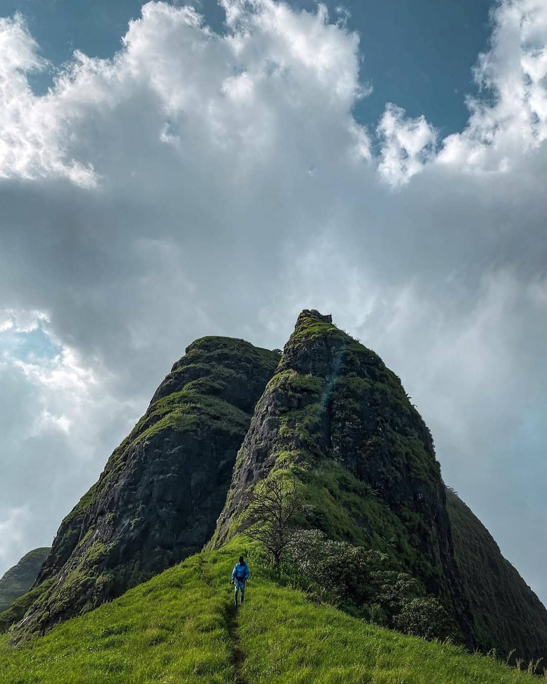
Sindola Fort, built around the same time as Nimgiri and Hadsar forts, was an observation point overlooking the stunning Malshej Ghat, Paragon Village, and other notable forts. This trek will not only reward visitors with stunning views of mountain ranges, reservoirs, and fortifications from the past but also give them a unique mix of natural beauty and history.

Highlights

  • Historic Significance:
  • Explore the ruin of Sindola Fort, including shattered bastions, water tanks from the past and an ancient Ganesha idol on its top which all echo the fort’s glory of its past.
  • Scenic Ridge walks:
  • Enjoy an adrenaline-inducing hike on the ridge, with breathtaking panoramas from the Pimpalgaon Joga reservoir, the stunning Western Ghats, and surrounding mountains like Devdandya, Bhojgiri, and Nimgiri Hanumantgad.
  • Unique Flora
  • Enjoy uncommon blooms, like the Karvi/Karwi flower and add vibrant hues on the path.
  • Panoramic views:
  • From the towering peaks of the fort take in the stunning panoramas of forts in the vicinity, including Harishchandragad Kulang and Harishchandragad — as well as iconic peaks such as Sisters Peak and Taramati Peak.

Trail Overview & Itinerary

Sindola Fort Trek The trek is best divided into three distinct sections, each with distinct encounters and challenges.

Section 1: From the Starting Point to the First Ridge

  • Starting Point:Location: Karanjale Village (Coordinates approximately 19deg19’12.7”N, 73deg48’52.9”E)How to Get There:It is easily accessible via public transport or private vehicles through Karanjale Phata. A signboard along the highway close to Karanjale will guide you to the start of your trek.
    • Location: Karanjale Village (Coordinates approximately 19deg19’12.7”N, 73deg48’52.9”E)
    • How to Get There:It is easily accessible via public transport or private vehicles through Karanjale Phata. A signboard along the highway close to Karanjale will guide you to the start of your trek.
      • It is easily accessible via public transport or private vehicles through Karanjale Phata. A signboard along the highway close to Karanjale will guide you to the start of your trek.
  • Trail Description:Start your journey in the broad fields near the highway, then gradually move to an elevated plateau.After approximately 20 minutes on numerous small pathways, you can follow the right side of the trail, which leads to a palace-like building reminiscent of the fort.Continue to walk up a gradual stroll (approximately 15 mins) until you come to the narrow trail on the left, which leads to a second ridge.
    • Start your journey in the broad fields near the highway, then gradually move to an elevated plateau.
    • After approximately 20 minutes on numerous small pathways, you can follow the right side of the trail, which leads to a palace-like building reminiscent of the fort.
    • Continue to walk up a gradual stroll (approximately 15 mins) until you come to the narrow trail on the left, which leads to a second ridge.
  • Notable Sights:Enjoy views of the Pimpalgaon Joga reservoir on your right and the surrounding mountains–Devdandya, Bhojgiri, and the forts of Malshej Ghat–in the distance.
    • Enjoy views of the Pimpalgaon Joga reservoir on your right and the surrounding mountains–Devdandya, Bhojgiri, and the forts of Malshej Ghat–in the distance.

Section 2: Ridge Walk & Traverse

  • Ridge Climb:First Ridge Position Coordinates around 19deg18’57.80”N, 73deg48’35.86”EAscend the ridge and then going back to the point of departure for your traverse.Time: Approximately 25-30 minutes.
    • First Ridge Position Coordinates around 19deg18’57.80”N, 73deg48’35.86”E
    • Ascend the ridge and then going back to the point of departure for your traverse.
    • Time: Approximately 25-30 minutes.
  • Traverse Starting Point:Location: Approximately 19deg19’13.76”N, 73deg48’16.78”EWhen you get closer to this point, a stunning panorama unfolds as you look over the Pimpalgaon Joga dam and get a glimpse of Harishchandragad and nearby peaks on the other side.
    • Location: Approximately 19deg19’13.76”N, 73deg48’16.78”E
    • When you get closer to this point, a stunning panorama unfolds as you look over the Pimpalgaon Joga dam and get a glimpse of Harishchandragad and nearby peaks on the other side.
  • Notable Sights:As you climb the ridge, get a view of several Forts (Devdandya, Bhojgiri, Nimgiri as well as Hanumantgad) and the expansive Western Ghats.Stop for a moment to take in the stunning scenery as well as capture the scene.
    • As you climb the ridge, get a view of several Forts (Devdandya, Bhojgiri, Nimgiri as well as Hanumantgad) and the expansive Western Ghats.
    • Stop for a moment to take in the stunning scenery as well as capture the scene.

Section 3: Final Ascent to Sindola Fort

  • Ascent Details:The trail follows an avenue lined by high grasses and wildflowers (including the Karvi/Karwi flowers that bloom in the spring).The path may be difficult at times, especially when the path appears less clear among natural grasses. So be aware and pay attention to the markings.Steps carved from rock allow access to the fort, but in the rainy season, the surface becomes slippery, making them treacherous.
    • The trail follows an avenue lined by high grasses and wildflowers (including the Karvi/Karwi flowers that bloom in the spring).
    • The path may be difficult at times, especially when the path appears less clear among natural grasses. So be aware and pay attention to the markings.
    • Steps carved from rock allow access to the fort, but in the rainy season, the surface becomes slippery, making them treacherous.
  • At the Summit:When you reach the fort’s top elevation, you’ll see the entryway marked with an Ganesha statue.In the fort, you can find several water storage tanks (some are still operational, even though the water quality is different) and take in the stunning panoramic views of the surrounding mountains and forts.
    • When you reach the fort’s top elevation, you’ll see the entryway marked with an Ganesha statue.
    • In the fort, you can find several water storage tanks (some are still operational, even though the water quality is different) and take in the stunning panoramic views of the surrounding mountains and forts.
  • Descent:Follow your route carefully. It’s the same path, but extra care is necessary on rocky or loose gravel areas. For your safety, you should use trekking poles. protection.
    • Follow your route carefully. It’s the same path, but extra care is necessary on rocky or loose gravel areas. For your safety, you should use trekking poles. protection.

How to Reach Sindola Fort

By Private Vehicle

  • The route from Mumbai:Journey from Mumbai through Thane via Mumbai Agra National Highway (NH160) and then follow NH61 toward Karanjale Village.Approximate Distances:Mumbai to Thane: ~49 kmThane from Karanjale Village: ~93 km (total distance to Mumbai 135 km)Find your “Karanjale Village Board” sign for the location of the start location in the field adjacent to it.
    • Journey from Mumbai through Thane via Mumbai Agra National Highway (NH160) and then follow NH61 toward Karanjale Village.
    • Approximate Distances:Mumbai to Thane: ~49 kmThane from Karanjale Village: ~93 km (total distance to Mumbai 135 km)
      • Mumbai to Thane: ~49 km
      • Thane from Karanjale Village: ~93 km (total distance to Mumbai 135 km)
    • Find your “Karanjale Village Board” sign for the location of the start location in the field adjacent to it.

By Public Transportation

  • Train and Bus Options:From Mumbai Take trains to Mumbai CST towards Kalyan. Trains operate frequently (every 15 minutes for many routes).From Kalyan, the bus heads towards Ahmednagar and stops in Karanjale Phata. Bus prices typically range from around Rs70 to 80 (or a little higher in air-conditioned alternatives).Make sure to confirm with the driver that the bus route takes straight towards Karanjale Village.
    • From Mumbai Take trains to Mumbai CST towards Kalyan. Trains operate frequently (every 15 minutes for many routes).
    • From Kalyan, the bus heads towards Ahmednagar and stops in Karanjale Phata. Bus prices typically range from around Rs70 to 80 (or a little higher in air-conditioned alternatives).
    • Make sure to confirm with the driver that the bus route takes straight towards Karanjale Village.

Alternate Routes

  • Other Entry Points:Karanjale Phata and Karanjale, along with Pargaon Phata, are accessible via the public transportation system.After you’ve reached the drop-off location, follow the local signage to the trek to Sindola Fort.
    • Karanjale Phata and Karanjale, along with Pargaon Phata, are accessible via the public transportation system.
    • After you’ve reached the drop-off location, follow the local signage to the trek to Sindola Fort.

Essential Tips & Packing List

  • Footwear & Clothing:Make sure you wear sturdy hiking shoes with good grip. Some rocks and loose gravel can be slippery.Layers of clothing are essential. Light outfits for warm days and an additional layer for colder temperatures, particularly in the early morning and winter hikes, are recommended.
    • Make sure you wear sturdy hiking shoes with good grip. Some rocks and loose gravel can be slippery.
    • Layers of clothing are essential. Light outfits for warm days and an additional layer for colder temperatures, particularly in the early morning and winter hikes, are recommended.
  • Hydration & Snacks:Take at least 3-4 Liters of water per day The water supply within the fort are not reliable.Include high-calorie foods like dried fruits, nuts and energy drinks.
    • Take at least 3-4 Liters of water per day The water supply within the fort are not reliable.
    • Include high-calorie foods like dried fruits, nuts and energy drinks.
  • Trekking Accessories:Poles to trekk with for stability when on the steep slopes.An emergency kit that contains the important items (band-aids and antiseptics as well as painkillers. ).Sunscreen (SPF 50plus) as well as sunglasses and a cap or a bandana.A light poncho or rain jacket is ideal to be worn during monsoon season.
    • Poles to trekk with for stability when on the steep slopes.
    • An emergency kit that contains the important items (band-aids and antiseptics as well as painkillers. ).
    • Sunscreen (SPF 50plus) as well as sunglasses and a cap or a bandana.
    • A light poncho or rain jacket is ideal to be worn during monsoon season.
  • Other Essentials:An unplugged mobile cellphone (network coverage is accessible at the beginning, but is limited during the hike).Small denominations of cash (ATMs are scarce, and Murbad is the closest station).Identity, Emergency Contact information as well as any permits required.
    • An unplugged mobile cellphone (network coverage is accessible at the beginning, but is limited during the hike).
    • Small denominations of cash (ATMs are scarce, and Murbad is the closest station).
    • Identity, Emergency Contact information as well as any permits required.

Best Time to Trek

  • Ideal Seasons:May-June and September-October : Experience lush green landscapes with blooming wildflowers and moderate temperatures.November to February: Ideal for clear panorama perspectives of Sindola Fort and the surrounding mountains.
    • May-June and September-October : Experience lush green landscapes with blooming wildflowers and moderate temperatures.
    • November to February: Ideal for clear panorama perspectives of Sindola Fort and the surrounding mountains.
  • Avoid:Monsoon Months The slippery paths as well as the strong winds could make walking dangerous.The peak summer season: High Temperatures can cause the terrain to be difficult and difficult to navigate.
    • Monsoon Months The slippery paths as well as the strong winds could make walking dangerous.
    • The peak summer season: High Temperatures can cause the terrain to be difficult and difficult to navigate.

Nearby Attractions

  • Pimpalgaon Joga Dam: Take in the views of the reservoir and think about a night-time camp close to the dam following your hike.
  • Other Forts & Peaks: To extend your trip, visit Harishchandragad Fort, Sisters Peak, Taramati Peak, and numerous other places in the Malshej Ghat region.
  • Local Villages: Discover nearby villages like Karanjale and Pargaon to discover the the local cuisine and culture.

Emergency Information

  • Medical Facilities: Prathamika Arogya Kendra-Madh Hospital About 4 kilometers to Karanjale Village.
  • Police: Junnar The Police Station: Located within Karanjale, about 20km from where the trek begins.
  • Emergency Number: Contact 112 for a national emergency call.
  • ATMs: The closest ATM is in Murbad. Make sure you have enough cash to avoid problems.

Sindola Fort Trek is a thrilling mix of nature, history, beauty, and physical challenges. The well-marked trails are accompanied by breathtaking views of ridges and sweeping landscapes. This is the perfect adventure for those who have previous hiking experience and want to experience the diverse cultural history as well as the stunning scenery in the Western Ghats.

Have fun trekking and take pleasure in the trip through time as well as the beauty of nature!

Table Of Content

  • Highlights1
  • Trail Overview & Itinerary2
  • How to Reach Sindola Fort3
  • Essential Tips & Packing List4
  • Best Time to Trek5
  • Nearby Attractions6
  • Emergency Information7

About the Author: Trekking Expertise You Can Trust

Kanishk

Kanishk s

Content Writer

Kanishk has lived in these hills all his life, so every time he wished to travel somewhere, the hills were his calling card. He completed his schooling in Dehradun and graduated with a degree in Journalism and Mass Communication. As a result, he was open to sharing in detail his personal experience of exploring with friends and his family. He then looked through different career choices but couldn’t find something that made him happy and content. Until he got an opportunity to work in a traveling company and that to trekking. In his mind, this was like the mountains calling, and he began explaining the adventure of going to the hills to people.