Trekup India
Upcoming Treks
Trek Gears Tips & ReviewsTrek GuideSave The TrailTrekkers Corner and SpaceTrekup India on Trek ProtocolTrekking and HealthSeason Wise Trek GuideTrekking TipsTravel Tips & Guides
Customize TrekSchool/College ProgramsBoardroom to Basecamp
All Trekpedia TreksTreks in UttarakhandTreks in Himachal PradeshTreks in Jammu & KashmirTreks in NepalTreks in SikkimTreks in Karnataka
Trekup India
Explore
Upcoming Treks
Trek Gears Tips & ReviewsTrek GuideSave The TrailTrekkers Corner and SpaceTrekup India on Trek ProtocolTrekking and HealthSeason Wise Trek GuideTrekking TipsTravel Tips & Guides
Customize TrekSchool/College ProgramsBoardroom to Basecamp
All Trekpedia TreksTreks in UttarakhandTreks in Himachal PradeshTreks in Jammu & KashmirTreks in NepalTreks in SikkimTreks in Karnataka
About UsCustomize TrekRent Trekking GearsBuy Trekking GearsOLDP For Schools & CollegesCorporate Trekking ProgramsApply For JobSave The TrailContact UsKnowledge Base

More options

About UsCustomize TrekRent Trekking GearsBuy Trekking GearsOLDP For Schools & CollegesCorporate Trekking ProgramsApply For JobSave The TrailContact UsKnowledge Base

Affiliation & Recognition's

INDIAN MOUNTAINEERING FOUNDATION

INDIAN MOUNTAINEERING FOUNDATION

APEX NATIONAL BODY

Affiliation

UTTARAKHAND TOURISM DEVELOPEMENT BOARD

Department of Tourism, Government of Uttarakhand

Affiliation

ADVENTURE TOUR OPERATORS ASSOCIATION OF INDIA

Header image logo

The material and pictures displayed on this website are protected by copyright, and the rights belong to the rightful owners. The purpose of using the material and images on this site is to showcase the works and does not indicate any endorsement of the artist. Unauthorized use is not allowed and may lead to legal consequences.

Quick Links

  • Treks Policy Terms and Conditions
  • Treks Terms and Conditions
  • Cancellation Policy
  • Website Policies

Contacts

  • 17 – A, Indrapuram, G. M. S Road, Dehradun, Uttarakhand, 248001
  • info@trekupindia.com
  • +918062358605
© 2026 TrekUp India. All rights reserved.

Kothaligad Trek

Kothaligad Trek

Article Published On - -

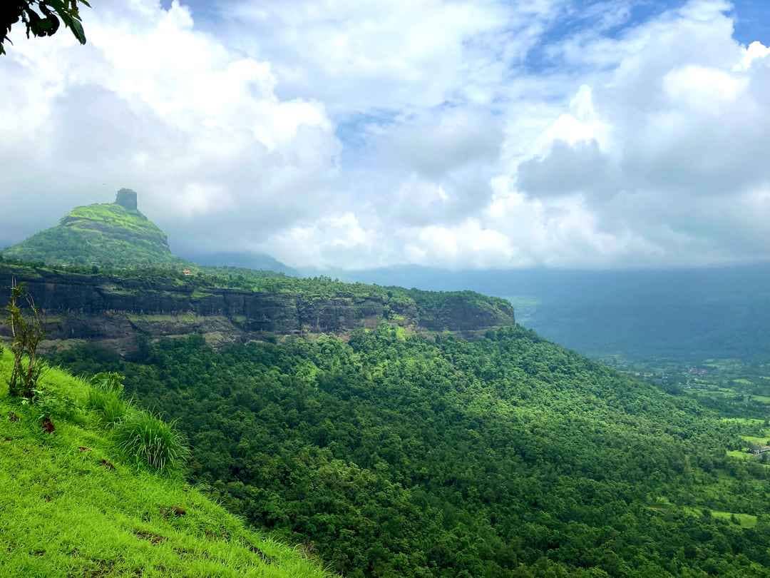
The lush area in The Bhimashankar Wildlife Sanctuary in Karjat, Kothaligad (commonly called Peth Fort) stands as an example of the once prevalent craftsmanship. Famous for its unique stone-cut caves, step-wells and traces of military structures, The 2 033 feet (620-meter) hillfort is a perfect blend of heritage and the beauty of nature.

A glimpse into the past dating back to the Maratha period, Kothaligad served as a strategically-designed watchtower and a storage facility for supplies to the military, and played crucial roles during the shifting power systems. This compact fort, complete with its signature pinnacle and water reservoir from decades past, as well as an altar dedicated to Ganesha, the local god, has dual functions as both a defence stronghold and a spiritual centre.

At the top it rewards hikers with panoramic views that span The Sahyadri range. When the skies are clear the horizon reveals the most famous landmarks, including Padargad, Malanggad, Siddhagad, Chanderi Fort, Bhimashankar as well as The Matheran Plateau – a sight-seeing delight for both those who love history as well as nature lovers alike.

Just 100 kilometers between Mumbai as well as Pune easy access by Karjat’s highly-connected rail network, Kothaligad is an ideal excursion for the day. The trek is moderate in nature and takes about a half-hour, with shaded trails as well as fascinating caves to explore along the way. Although winters (November-February) are cool and cloudy, and misty days that are ideal to hike and hiking, the monsoon period (June-September) changes the trail into a lush landscape dotted with waterfalls.

Why you shoud Do Kothaligad Trek?

If you’re interested in the historical history, architecture marvels or tranquil wildness, Kothaligad promises a refreshing getaway from the chaos of urban life. Bring your camera and tie on your shoes, and discover the mysteries of this elusive Sahyadri treasure!

Pro TIP: Combine your visit to the Bhimashankar Temple, or take a swim into the Ulhas River for a full-day experience in the natural world and history.

Best Time for Kothaligad Trek

Best Time Summary

SeasonHighlightsBest For
MonsoonWaterfalls, mist, lush trailsAdventure seekers, photographers
WinterClear views, cool weatherFamilies, casual trekkers, history buffs
SummerSolitude, dry pathsEarly risers, experienced trekkers

Pro TIP: for a truly memorable adventure, go in the monsoon’s last days (September), during which the rainfall is less intense, yet the beauty of the area remains. If you are able, avoid weekends so that you can avoid the crowds.

Highlights of Kothaligad Trek

  1. Monsoon Magic: Misty trails, waterfalls, Emerald landscapes.
  2. Historical Marvels: Rock-cut reservoirs, defense structures, escape routes.
  3. Local culture Lemonade stalls at weekend, village chickens darting across the paths.
  4. Cave Exploration: Explore hidden shrines, as well as The Bhairavnath Temple.

Detailed Trail Information Of Kothaligad Trek

  • Difficulty: Moderate (challenging in monsoons)
  • The duration of the trek: 1.5-2 hours (core trek) • approximately 4-5 hours (with exploring)
  • Distance 4 km (Ambivli to the summit)
  • Height Gain 800-ft (Ambivli at 460 feet, Summit 2 033 feet)
  • The best time to visit Monsoon (June-Sept) and Winter (Nov-Feb) to enjoy clear views
  • Entrance Fee: Rs50/person (Peth Gaon) | Local Guide: Rs50/person (recommended)

Route Breakdown

1. Ambivli to Peth Gaon (4 km | Gentle Ascent)

  • Begin with Kanda Pohe as well as coffee on Ambivli’s stalls.
  • Continue on a well-paved road for 500m. After that, proceed to the upward trail on the left-hand side.
  • Go over the monsoon-fed Peth Plateau (waterfalls to you left).
  • The trail turns to dirt, cycling enthusiasts often descend from here.

2. Peth Gaon to Kothaligad Summit (1.6 km | Steep Climb)

  • On the village fork, select:Straight route towards the fort (shorter and more steep).Edge route that is scenic (rice fields view, Hamlet view).
    • Straight route towards the fort (shorter and more steep).
    • Edge route that is scenic (rice fields view, Hamlet view).
  • Take a stroll along narrow trails, rock steps and monsoon rivers.
  • Find the Fort’s entrance Steps that are ancient and carved in the rocks will lead you to reservoirs, caves as well as the famous chimney stairs up to the top.

3. Summit Highlights

  • Bhairoba Cave: Cut into intricate rocks and bat colonies.
  • the Lion Elephant Gate ornate carvings mark the highest point.
  • 360deg views: Bhimashankar range, Matheran plateau and the neighboring forts.

Alternative Routes

  1. Jamrung-Upper Peth Gaon – The area is less crowded, however it crosses private property (seek approval).
  2. Bhalwadi/Padharwadi-Nakhind Tok – Connects with Bhimashankar Plateau; requires expert guide.

How to Reach For Kothaligad Trek

By Air: Nearest Airport – Mumbai (Chhatrapati Shivaji International) – 100 km.

By Road: To Mumbai/Pune (Mumbai/Pune): Take a drive to Karjat (2 hours) Ambivli (23 km via the Kashele-Peth Highway). | Google Maps Link: Kothaligad Trek Route

By Public Transport:
  1. Train: Mumbai/Pune to Karjat Station.
  2. The bus: Karjat Depot to Ambivli (ask for “Kothaligad Trek stop”).

Essentials for the Kothaligad Trek

  1. Pack light: Food, water, a raincoat (monsoon), and trekking footwear.
  2. Combination Trips: The itinerary includes – Bhimashankar Temple or Ulhas River post-trek.
  3. Post-Trek Treat: Refuel at Peth Gaon’s Bhairavnath Bhojanalay.

Table Of Content

  • Best Time for Kothaligad Trek1
  • Highlights of Kothaligad Trek2
  • Detailed Trail Information Of Kothaligad Trek3
  • Route Breakdown4
  • How to Reach For Kothaligad Trek5
  • Essentials for the Kothaligad Trek6

About the Author: Trekking Expertise You Can Trust

Shivam

Shivam Shingari

Head Of Mountain Experts

-