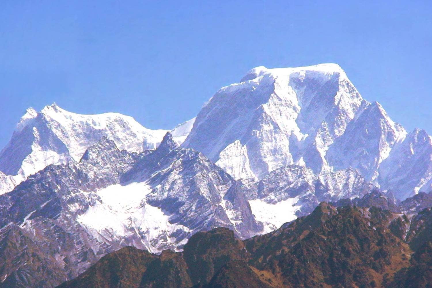
The world-renowned Kanari Khal Trek in the Garhwal Himalayas offers various natural marvels. These include flowing rivers, cascading waterfalls, lush alpine meadows, picturesque mountain villages with lush forests, and vibrant colors. When trekkers travel through the mysterious scenery of Uttarakhand’s Garhwal Himalayas, they can enjoy stunning landscapes across their Kanari Khal Pass trail.
The trek is also a chance to enjoy the relaxing music of the numerous streams, which flow gently throughout the spring and summer seasons but then swell to an eerie roar in the winter.
On the way, travelers can explore the most important Hindu places of pilgrimage, such as Rishikesh, along with the close Dronagiri village and Joshimath. The areas offer a fantastic opportunity to see the magnificent mountain ranges in Changbang, Garure Dome, and Kalanka and a view of the majestic Lampak mountain ranges. This thrilling adventure has been designed for mountain adventurers and thrill seekers, offering an unforgettable trip by taking this Kanari Khal Trek.
Trekkers often cite that journeying to Bagini Glacier or Changabang Base Camp can be risky due to unpredictable weather and difficult terrain. However, Kanari Khal in Joshimath offers an exciting alternative. Located about 11km away at an elevation of 4,150m, this area provides the ideal combination of challenges, natural beauty, and adventure! The trek along its mountain ridge offers both an opportunity for natural exploration and an adventurous expedition.
Kanari Khal is an unforgettable trek, filled with picturesque rivers, lush grasslands, cascading waterfalls adorned with vibrant wildflowers, high mountain peaks topped with snow-covered summits, dense forest terrain, and gorgeous mountain villages. If you plan on visiting Joshimath or Badrinath soon enough, ensure that part of your visit includes this rewarding trek as part of its itinerary!
Best Time for Kanari Khal Trek
To ensure the best hiking experience in Kanari Khal, you must plan your trek through the seasons below:
- Spring (March to May):Conditions: Mild temperatures and flowering flowers make the trails picturesque and colorful.Condition: The trails are generally free of snow, so the chance of getting snowed in is very low, making for safer walking conditions.
- Conditions: Mild temperatures and flowering flowers make the trails picturesque and colorful.
- Condition: The trails are generally free of snow, so the chance of getting snowed in is very low, making for safer walking conditions.
- Autumn (September to November):The weather: Crisp, cool, and clear, the air provides great visibility and comfortable walking conditions.The conditions are: The post-monsoon environment ensures that the trails remain stable, while the fall shades make the natural landscapes stunning.
- The weather: Crisp, cool, and clear, the air provides great visibility and comfortable walking conditions.
- The conditions are: The post-monsoon environment ensures that the trails remain stable, while the fall shades make the natural landscapes stunning.
Beware of the monsoon season (June through September) due to slippery roads and landslides. Be aware during winter (December through February), when heavy snowfall and severe cold could cause dangers when trekking. Have fun with Kanari Khal at the time that best matches your style of trekking!
Highlights of Kanari Khal Trek
- Stunning Summit Vistas:You can reach a mountain saddle, which offers stunning panoramic views of Dunagari and the surrounding mountains.Be amazed by the breathtaking view at Nandi Kund Pass emerging on the ridgeline. This adds a striking contrast to the landscape.
- You can reach a mountain saddle, which offers stunning panoramic views of Dunagari and the surrounding mountains.
- Be amazed by the breathtaking view at Nandi Kund Pass emerging on the ridgeline. This adds a striking contrast to the landscape.
- Challenging Yet Rewarding Ascent:Take on a narrow, steep shepherd’s trail that winds through high grassy fields and small gorges.Enjoy the excitement of climbing rough terrain and making each move satisfying.
- Take on a narrow, steep shepherd’s trail that winds through high grassy fields and small gorges.
- Enjoy the excitement of climbing rough terrain and making each move satisfying.
- Diverse Terrain:The landscape you traverse changes between tightly controlled switchbacks and large, open lines.Look at the intricate interplay of the natural and rocky outcrops that define this mountain trek.
- The landscape you traverse changes between tightly controlled switchbacks and large, open lines.
- Look at the intricate interplay of the natural and rocky outcrops that define this mountain trek.
- Unspoiled Natural Beauty:Enjoy a world that changes at every turn, revealing breathtaking mountain panoramas.Explore the tranquil, unspoiled wildness that makes Kanari Khal a real hidden treasure for hikers.
- Enjoy a world that changes at every turn, revealing breathtaking mountain panoramas.
- Explore the tranquil, unspoiled wildness that makes Kanari Khal a real hidden treasure for hikers.
The highlights of these make this Kanari Khal trek an incredible adventure, offering physical challenges and breathtaking natural landscapes throughout the area.
Kanari Khal Trek Detailed Trail Information
The multi-day trek commences at Joshimath and leads travelers through various landscapes, from rough mountain roads to lush forests, challenging climbs, and peaceful camping spots. This is a complete daily schedule.
Day 1: The trek begins at Joshimath and ends at Jumma. Then, Trek up to Ruing Village.
Driving Segment:
- Directions and Time: Drive around 3 km from Joshimath to Jumma (allow about 3 hours if you consider the roads difficult).
- The road takes you through picturesque villages, including Tapovan, Reni, Lata, Suraithota, and Phagti, as it follows the beautiful Dhauliganga River.
- Start with Jumma within an hour after departing Joshimath.
- Buy the necessary items for trekking and kerosene prior to starting. If the supplies are not sufficient, Stops at Suraithota along the route will provide enough relief.
- Situations: Be aware that the route is risky during the monsoon because of heavy rainfall and its proximity to the Tibetan border.
- An intense afternoon breeze in Jumma could intensify after you leave your car.
Trekking Segment:
- Start Point: Begin by crossing the iron bridge that spans the Dhauliganga River. Dhauliganga River.
- Route: Cross the bridge, then follow gradually rising slopes upwards through the forests to Ruing Village (approximately 3 km).
- Ruing Village: A tiny settlement with the possibility of two or three homes and a small shop selling necessities.
- The accommodation is readily available. However, the authorities in your area might limit the duration of your stay. If this happens, you might consider going to a meadow nearby before you begin the Dronagiri ascent.
- The meadow campsite provides a stunning natural setting but also helps make the climb up to Dronagiri more comfortable.
Day 2: Walk to Ruing up to Dronagiri Village
Elevation & Distance:
- Elevation Range: 2,800 m to 3,610 m.
- Distance: Around 8km, an average of 5-6 hours.
Route Details:
- Start the trek towards Dronagiri with a smooth and well-marked forest trail.
- Shortly after you have set off the road, you’ll come across an area susceptible to slide.
- At the trail’s point of divergence, you can take the climb path, which was once a route to Dronagiri through vast glaciers close to the Nandikund region.
- The trail runs through a remote gorge filled with loose rocks and other debris. Without local guides and porters, this section could be difficult.
- Climb Features: A steep section with steep slopes of about 60 degrees and several streams that cross.
- Take in breathtaking panoramas of snow-capped mountains like Hathi Parvat and Ghori Parvat. During the summer months, flowering wildflowers enhance the scenery.
Arrival in Dronagiri:
- After reaching Dronagiri, Follow an asphalt path until the indications of the decrepit town show up.
- NOTE: Dronagiri lacks shops; The nearest market is 20 km from Suraithota.
- Two campsites are accessible in the Dronagiri area: one is in the suburbs, and one is close to the GMVN facilities.
- Local rates can be negotiated (e.g., the most recent rates are around Rs.1,500 for an evening).
- Local Highlights: Discover town services like satellite phones to make local calls and streetlights powered by solar energy.
- The temple, built in honor of Bhumial, is situated on the most elevated point in this village, from which Mount Dunagiri is visible.
Day 3: Trekking to Dronagiri towards Longatulli
Elevation & Distance:
- Elevation Range: 3,610 m to 3,800 m.
- Distance: Approximately 3km; the estimated travel time will be around three hours.
Route Highlights:
- The trail leaves Dronagiri and follows a high ridge that provides a stunning view of Rishi Peak and Bagini Nala.
- The Key Landmark: Soon after leaving the bridge, you’ll cross Bagini Nala.
- Optional Route: At the bridge, the path diverges to Kanari Khal and eventually to Garpak Village. However, for this trip, go upwards straight ahead on a rocky route with solitary vegetation.
- In the first 90 minutes after crossing the bridge, a patch with greenery close to a stream is a good camping spot in the event of an emergency.
- Progression: Continue trekking:
- In about two hours, you can reach Bagini Lower Base Camp at 12,360 feet, where you can view Rishi Pahar, Satminal, and Hardeol mountains.
- Go for four more km and then follow a 45-minute trek to reach Bagini Upper Base Camp.
- Then, a beautiful climb brings the visitor up to Bagini Advanced Base Camp at 15,530 feet.
Trail Conditions:
- The trail generally stays steady, but it occasionally climbs abruptly.
- Early mornings are perfect for traveling through the Bagini Nala/Garud stream, with the water level rising later in the day.
- Navigation is made easier by Cairns (stone stacks) that mark the route.
- In Garud Base Camp (also known as Bagini Glacier), pause momentarily to gaze at the mist-shrouded and frozen mountain views.
- Notice: The evenings in Longatulli are typically very cold, so plan for an unhurried return.
Day 4: Walk to Longatulli Camp to Garpak via Kanari Khal
Elevation & Distance:
- Elevation Range: 3,800 m to 3,340 m.
- Distance: Approximately 13 km; expect an 8-9 hour trek.
- Route Overview:Begin at the junction bridge over the Bagini River near Bagini Glacier.Left and ascend an icy, small path. It is a shepherd’s route that curves through the high grassy field.Continue to Kanari Khal, a mountain saddle visible following the passage of a slender valley.
- Begin at the junction bridge over the Bagini River near Bagini Glacier.
- Left and ascend an icy, small path. It is a shepherd’s route that curves through the high grassy field.
- Continue to Kanari Khal, a mountain saddle visible following the passage of a slender valley.
Climb Details:
- Ascending Kanari Khal typically will take approximately an hour.
- From the top, enjoy stunning panoramas of Dunagari, its surrounding peaks, and Nandi Kund Pass, visible on the left.
Descent Options:
- At the top, Two paths are apparent:
- Right: Leads toward Kalla Khal.
- Left: Leads to Garpak Village.
- The climb to Garpak is treacherous in particular:
- Take a trip of 800 meters through smooth, slippery, grassy ridges and fast switchbacks.
- The typical descent covers about 4km in four hours.
Day 5: Trek from Garpak Through the Ruing route to Jumma and then back the way you came from to Joshimath
- Time and Distance: Approximately 8 km. It is covered in 7 to 8 hours.
- Highlights: Following a tiring and exhausting day, you can enjoy a picturesque trek across the Lampak and Bagini streams.
- Key Landmarks: Approximately 1 km from Garpak, cross an overpass spanning the Lampak stream.
- Follow the stream downstream to where Lampak rejoins Bagini stream. Then, cross the next bridge to access Ruing village’s trail.
- Take this route until you rejoin the route in Jumma.
- Return Segment: When you return to Jumma, you can arrange a Jeep drive from Jumma to Joshimath to complete your journey.
The itinerary blends challenging trek sections with rewarding views, historical stops, and valuable suggestions for safety and navigation. Ensure you are prepared and ready for the most unforgettable journey in this breathtaking scenery.
How To Reach
Joshimath is located approximately 273 miles from Rishikesh and Haridwar, making it an ideal destination for tourists. How to get there: Joshimath:
- By Train:Trains that overnight go to Delhi, Haridwar, and back. Trains typically arrive very early in the day.
- Trains that overnight go to Delhi, Haridwar, and back. Trains typically arrive very early in the day.
- By Road:From Haridwar, you can catch an auto or jeep for Joshimath. A bus or jeep leaves every day for Joshimath, and the travel time is usually about 10 to 12 hours.In Rishikesh, jeeps with shared seats can be rented in the Badrinath Road area near the GMVN Bharat Bhoomi Guest House.
- From Haridwar, you can catch an auto or jeep for Joshimath. A bus or jeep leaves every day for Joshimath, and the travel time is usually about 10 to 12 hours.
- In Rishikesh, jeeps with shared seats can be rented in the Badrinath Road area near the GMVN Bharat Bhoomi Guest House.
- Road Conditions & Scenic Routes:The roads leading to Joshimath are usually well-maintained. But, certain sections — particularly those between Srinagar, Rudraprayag, Chamoli, and Joshimath–may be bumpy.Explore scenic drives in Devprayag, Srinagar, Rudraprayag, Karanprayag, and Chamoli and Chamoli, adding appeal to your travels.
- The roads leading to Joshimath are usually well-maintained. But, certain sections — particularly those between Srinagar, Rudraprayag, Chamoli, and Joshimath–may be bumpy.
- Explore scenic drives in Devprayag, Srinagar, Rudraprayag, Karanprayag, and Chamoli and Chamoli, adding appeal to your travels.
- Additional Access:Jumma Village, a nearby location, is easy to reach by Joshimath by a quick jeep ride.
- Jumma Village, a nearby location, is easy to reach by Joshimath by a quick jeep ride.
They offer flexibility and a fun method to plan your visit to Joshimath.