
Chandrabhaga Glaciers Trek
A Raw High Altitude Journey into Glacier Country
Trek Overview
Quick Facts
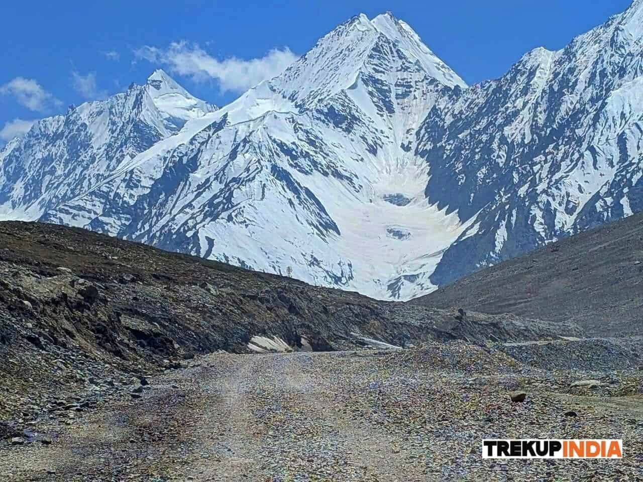
The Chandrabhaga Glaciers trek is among the most remote, rawest high altitude excursions in the Indian Himalayas. Beginning in Baralacha La Pass (16,040 feet) in Lahaul, Himachal Pradesh, this trek quickly immerses you in the stunning cold desert, a surreal glaciated landscape where towering Himalayan mountain peaks collide with ancient glaciers, frozen streams, and unspoiled alpine plateaus.
As you trek through this amazing terrain, you walk through the massive silhouettes of the Chandrabhaga ranges, witnessing glaciers fall down the rock faces and the emergence of the Chandra River, a major tributary of the Indus. The trail is also a route to two high-altitude lakes, Kya Tso and Ga Tso. Kya Tso and Ga Tso, which lie in a quiet place in the snow-covered slopes of Mt. Yunam Peak with an elevation of more than 17,000 feet.
This trek is more than an enjoyable hike; it’s a glaciology display that’s moving. There are icefalls, crevasses, sinkholes, and glacial snouts at a non-technical, safe distance, which makes it a unique experience accessible for trekkers who do not have any mountaineering experience.
The trek shows the stunning, moon-like beauty of Lahaul’s harsh desert. The vast, bare landscape is ablaze with gorgeous shades of green, orange, and purple with changing light – a striking hue that can only be seen in the high Himalayas.
One of the most memorable parts of the trek includes the “Silver Moraine Campsite,” nestled in a glacial stream, and set among massive peaks like KR 5 Kullu Makalu, and Mt. Yunam.
This trek will take you close to glaciers, without the dangers of walking on the tops of them. You’ll see the formation of glaciers, moraine ridges, icefalls, along with the glacial outcrops in a manner that very few treks in india permit, providing a unique learning and visual experience.
Take a look at the snout, where you can see the Chandra River emerges from the ice. This river eventually changes into the Chenab River. It is an essential system of waterways that runs throughout Jammu & Kashmir, Punjab, and eventually to the Indus in Pakistan – an event of pure nature and scale.
The climb over the ridges of a moraine littered with boulders is rewarded by the sight of Kya Tso, Kya Tso, and Ga Tso, three glacial lakes perched high up in the mountains. The lakes are not visible until the last stage of the climb, which makes their discovery amazing.
Short and Detailed Itinerary, Trek Map and Altitude Chart of Chandrabhaga Glaciers Trek
This section provides a comprehensive, simple explanation of the Chandrabhaga Glaciers Trek, including general day-to-day routing, elevation gain, etc. The basic itinerary is designed to give an overview of the trek; all-inclusive itinerary allows for a more in-depth understanding of the various distances between campsites, the nature/type of terrain that trekkers will be traversing, and the locations of the campsite relative to one another.
In addition to the above, the trek map indicates the specific route of the trekking path, village locations, forest locations, and campsite locations within the trek area enabling trekkers to imagine their trek through snow-covered coniferous forests and alpine meadows. The elevation chart clearly indicates the total elevation gained and lost each day of the trek ensuring that trekkers can prepare adequately before arriving at the basecamp, acclimatize safely to altitude, and have a positive experience on their overall trek.
How to Plan Your Travel for Chandrabhaga Glaciers Trek
It’s important to note that all participants must reach Manali at the start of the program. To cater to your travel preferences, we offer three options:
Option 1: Consider traveling overnight on a government bus to Manali. The journey takes 14 hours from Delhi and 10 hours from Chandigarh. We strongly recommend government buses over private ones, as they are more reliable and less likely to be delayed. Regardless of your choice, aim to reach Manali between 9 and 10 am.
Option 2: If you prefer to fly, the best option is to fly to Delhi or Chandigarh airport, then take a bus to Manali. Another alternative is to fly to Bhuntar Airport, which is only two hours away from Manali. However, we advise against this due to the high flight costs and potential for cancellations. If you do choose to fly to Bhuntar, ensure you arrive at least a day before the trek begins.
Option 3: It is possible to go by train. Pathankot railway station, from where you can take bus services that direct you to Manali which is about 300 kilometers from the station and will require an overnight trip. If you choose this option, it is best to arrive one day prior to Manali.
Rest assured, when you arrive at the trek assembly point in Manali, Trekup India will take care of your journey to Jobra, Chatru, and back to Manali, including an excursion to Chandratal. Please ensure you reach Manali before 10:30 am on the first day of the program to allow for a timely departure to the assembly point.
Safety Aspects and Emergency Exit for Chandrabhaga Glaciers Trek
1. Understanding Trek Safety
Trekking with us for the Chandrabhaga Glaciers Trek is entirely safe because we have a team of trek leaders qualified in Wilderness first-aid and complete information about the high-altitude glitches. During the trek, we carry a full first-aid kit that contains all the essential medicines. Before trekking with us, you must ensure that you are medically fit for the trek; for us, your medical fitness is more important than anything else.
Right from our establishment, we at Trekup India have been continuously introducing new safety practices into Indian trekking to ensure the safety of voyagers. Trekup India introduced microspikes and made emergency bottled oxygen mandatory for all treks. Our trek leaders take your daily Pulse oximeter reading. We at Trekup India introduced the radio walkie-talkie as a safety communication device.
2. How can we ensure that your trek is safe with us?
We have noticed that most trek-organizing organizations do not follow these systems, but with time, they are following us; several competing companies are adopting these practices and organizing great, safe treks.
We ensure complete technical safety in the mountain. Our company has a vast team of more than 100 guides and trek leaders who serve on Himalayan treks. One of the best things about our team is that all the members are trained professionally by the Nehru Institute of Mountaineering, Indian Mountaineering Foundation Delhi, and Hanifle Center Outdoor Education Mussoorie.
3. Explore our New Safety Protocols
To ensure a perfect Trek, we have introduced some new safety checks to ensure excellent safety for our trekkers.
4. Our On-trek safety checks include:
- Daily oxygen saturation, along with pulse readings
- Stretchers team appointed on every trek
- Radios
5. For Us, Your Safety Is the Top Priority
At Trekup India, you will find a team with local knowledge and fluency in English and Hindi. This helps ensure that you have a fantastic trek. Not only this, but we also pay attention to your health and safety because this is something we cannot ignore. All the team leaders involved in trekking have already undergone several professional courses in first aid, portable altitude chamber training, CPR, environmental awareness training, and advanced wilderness emergency medicine.
We also carry a complete first aid medical kit on every trek and trip we organize. Apart from the medical kit, we take a portable altitude chamber (if needed) and medical oxygen for all high-altitude treks. Our company has significant expertise in organizing all sorts of group adventure holidays for family groups, school and college groups, and friend groups. We have many travel options that suit different fitness levels and travelling styles.
Regardless of the group size, we value each and every member of our trekking groups. Our commitment to personal attention ensures that your needs and safety are always our top priority.
6. Who we are?
Trekup India has been a stalwart in the Adventure Tourism industry for 30 years. Since our inception, we have been dedicated to providing top-notch treks, voyages, trekking programs, and high-altitude expeditions. Our extensive experience is a testament to our commitment to your adventure and safety.
We organize treks in Uttarakhand, Kashmir, Sikkim, and Himachal while being part of the trekking community; we feature more than 75 documented Himalayan treks. In addition to other outdoor activities, our company also organizes trips for schools, colleges, and families.
Therefore, we maintain the quality of services offered to our valuable customers.
The Essential Chandrabhaga Glaciers Trek Packing List: Pack for Adventure & Safety
- Extremity Protection: Must have UV blocked sunglasses (the only way to protect against snow blindness), waterproof gloves, and a warm balaclava/cap to protect your most exposed areas.
- Layering System: Utilize multiple layers of synthetic or wool insulation clothing (acceptable, no cotton) to manage body temperature and moisture to prevent chilling.
- Waterproof Footwear: Durable waterproof trekking boots at least mid-calf are required so your feet and ankles remain protected on snow and ice.
1.Major gears: The frontline of protection
| Item | Characteristic Feature | Pro-tip |
|---|---|---|
Waterproof, Ankle-Height Trekking Boots | These are high quality boots with stiff rubber soles that prevent water entry. | Must be fully broken in. Good with a deep aggressive grip to avoid injury in toe or fingers. |
Trekking Poles (Pair) | Provide 2 additional points of contact for stability on snow / ice and reduce impact on knees while descending. | Use them together to distribute the weight of your pack, this can reduce stress on your knees and ankles. |
Waterproof Gloves (2 pair) | Protects against cold injury. Having two pairs that allows warmth while protecting your hands. | Keep the shell of gloves dry for a waterproof layer for handling snow and keep the inner liner for warmth. |
Gaiters (required) | Create a seal between your boots and trousers to prevent snow from entering your boots / sock. | Put your gaiters on as soon as you reach the snowline; avoiding snow wetting your socks / boots minimizes risk for cold injury. |
High-Grade SPF Sunscreen and Lip Balm | Protects against severe sun / wind burn. It is important for exposed skin at high altitude due to reflection from snow. | Reapply sunscreen to face, neck, and ears every 2 hours spent on the snow. |
Sunglasses (Category 4) | Highest level of protection required to protect against temporary blindness (photokeratitis) | Do not remove sunglasses when you are on the snow because snow can reflect 80% of UV light back into your eyes. |
2.Clothing: The layering system
| Category | Item | Specification & Reason |
|---|---|---|
Headwear | Warm Beanie / Balaclava | Must be thick wool or fleece; cover the ears completely. Important in retaining body heat, as a large percentage of body heat is lost from the head. |
Wide-Brim Sun Hat or Buff | Light material (hat) or synthetic tube (buff). Protects face, neck, and scalp from high-altitude UV radiation from the sun. | |
Upper Body | Moisture-Wicking T-Shirts (2) | Choose Synthetic (polyester) or thin Merino wool; short or long sleeve because cotton actively makes you cold and uncomfortable when you sweat. |
Thermal Base Layer (1) | Mid-weight Merino wool or synthetic long-sleeve top. Provides immediate insulation; it will lock in body heat as the starting point of your heat-trapping system. | |
Fleece Jacket (1) | Mid-to-heavy weight (200-300 GSM) fleece or softshell jacket full of insulation. This layer provides the best warmth-to-weight ratio It can be worn alone or under your shell. | |
Insulated Puffed Jacket (1) | Down or synthetic insulation; rated for 0∘C and below. Your main source of heat protection for cold night camping, evening, and the summit push when below freezing conditions are anticipated. | |
Waterproof & Windproof Jacket (1) | Shell material (e.g. Gore-Tex equivalent) with taped seams. Your outer barrier (shell layer) keeps the rain, snow and penetrating wind out from the mountains. | |
Lower Body | Quick-Dry Trekking Pants (2) | Synthetic, lightweight, and preferably stretchable or convertible. Durable for comfortable walking, fast drying after getting wet from rain or snow. |
Thermal Base Layer (1) | Mid-weight thermal bottoms (wool or synthetic). Vital layer of insulation under your trekking pants in cold walking conditions at camp. | |
Waterproof Rain Pants (1) | Lightweight, packable shell pants. These will protect your trekking pants and base layers from getting wet when it's snowing or raining heavily. | |
For Feets | Create a seal between your boots and trousers to prevent snow from entering your boots / sock. | Put your gaiters on as soon as you reach the snowline; avoiding snow wetting your socks / boots minimizes risk for cold injury. |
Trekking Socks (4-5 pairs) | Wool or some kind of synthetic blend (not cotton). 1-2 pairs should be extraordinarily thick for nights. These will manage moisture in your foot to reduce blisters and provide warmth at night sleeping in a bag or in boots! | |
Camp Shoes | Lightweight sneakers, sandals, or slippers. You'll want these to dry out your trekking boots and let your feet rest when at the campsite. |
3.Equipment & Essentials
| Category | Item | Important Notes |
|---|---|---|
Backpacks | Main Rucksack (50-60 L) | For Porter. Good frame of posture and hip belt required. |
Daypack (20-30 L) | Daily carry. Must have water, layers, snacks, camera, and gloves in your daily essentials. | |
Sleeping bag & liner | Sleeping Bag (Rated to −10∘C / 14∘F) | Confirm if Trekup India provides a sleeping bag; if you're renting your bag, make sure it is a reputable outfit. |
Sleeping Bag Liner | A liner adds additional warmth and keeps your bag clean. | |
Hydration | Insulated Water Bottles (2x 1L) | CRUCIAL: No hydration bladders (the tube will freeze). Insulated bottles will keep your water from freezing. |
Hydration Tablets/ORS | Make sure you have enough hydration tablets and/or Oral Rehydration Solution (ORS) which are important for replacing electrolytes lost at high altitude. | |
Safety & Navigation | Headlamp with extra batteries | Essential for crossing the pass started early in the morning. |
Basic First-aid kit | With plasters (Compeed!), Band-Aids, antiseptic, pain medication, and then any of your personal medications you might need. | |
Personal | Personal toiletries | Toothbrush, tooth paste, biodegradable soap, toilet paper (pack out!), and hand sanitizer. |
Quick Dry Towel | Material should be water absorbent with light in weight and small in size. | |
Power bank | There will be no place to charge devices on the trek. |
4.Essential Documents
- Government-issued Photo ID
- Indians: Aadhar Card, Voter ID, or Driving License.
- Foreigners: Passport and Indian Visa.
- Must Have: Necessary for verification at the Basecamp and Forest Department checkpoints.
- ID Copies (2 copies): Also submitted for the forest authorities for required trekking permits, etc.
- Medical Certificate & Undertaking Form: a form (usually provided by your operator- Trekup India) signed by an MBBS registered doctor confirming that you are fit for high altitude trekking.
5.Important tips by the trek leader (from their experience)
- Three Second Rule: If you can’t immediately think of a reason to pack an item, simply don’t pack it.
- Layer Duplication Rule: You cannot pack more than two of the same, heavy layer (e.g., two heavy fleece jackets). A proper layering system will give one item a temperature range.
- Multi-Use Only: Every item should have a minimum of two functions (e.g., balaclava can be a sweat rag, shade your face from the sun, or act as a neck gaiter).
- Boot Break-In Rule: Don’t take new boots on a hike unless they have over 50 miles already walked in them. Boots need proper break-in time before using them outside.
- Base System Check: Set up your sleeping system (sleeping bag, liner, pad) in your house, on the day before the trek.
- Pack System Test: Wear your complete layering and set it up in similar cold/wet conditions to find any cold spots and distributed moisture.
- Comfort Item: Allow yourself one small item which is not a necessity. (ex. good book, tiny bottle of whiskey, small pillow).
- Ear Plugs: These are essential to block noise from the other trekker/ trek activities at the camp site ensuring you get your sleep without interruption.
- Camp Footwear: Lightweight flip-flops, Crocs, or just down booties that you can wear inside the tea house tent. Getting your feet out of your boots is total bliss.
- Carry Everything Out: This is the most important. Nothing goes under the ground or in a fire pit—especially plastic, tin foil, or batteries.
- Human Waste: If there are no bathroom facilities, you need to bury human waste to a minimum of inches deep at least away from any water source or trail. Be sure to pack out toilet paper.
6.Final Verdict:
Chandrabhaga Glaciers Trek Cost Inclusions and Exclusions
The concept of pricing is the key part of your trekking journey. It defines the value and experience you receive for the price you pay for your trek. For a structured high altitude trek, like Chandrabhaga Glaciers Trek operated by Trekup India provides transparency with the cost & amenities provided to our trekker. Inclusions provide clarity in respect to operator's responsibility; essentially every necessary service, logistical support, group equipment, and permit to have a safe and fully supported trek from start to finish while exclusions provide clarity in respect to individual's responsibility, for all expenses related to personal choice (like a porter), necessary contingency items (like insurance), or mandated fees examined outside the package price (like GST).
Total Trek Cost: ₹ 18,950 / person + 5% GST (Mandatory)
Trek Cost Inclusions
- Stay: 1 Night at Jispa in Hotel, and 4 Nights of tented accommodation at individual campsites of Trekup India on twin sharing.
- Meals: Trekup India will provide freshly cooked meals during the trek starting with Dinner on Day 1 to Lunch on day 5 (Meals are simple, nutritious, and vegetarian)
- Trek Equipment: Sleeping bag, Sleeping tents, Kitchen tent, Dining tent, Toilet Tent.
- Amenities: All utensils, sleeping mattresses (Black foam mats), Crampons, and Gaiters for snow.
- Health & Safety: First Aid Box, Oxygen Cylinders, Stretchers, Oxi meters, BP Machines, health.
- Permits: Forest Permits and Camping Permission Fee
- Trek Crew: High Altitude Chef, Helpers, Trek Leader & Guides, and other support teams.
- Potters & Mules: Potters and Mules are to carry all trekking equipment, ration, and vegetables.
Fitness Required & Preparation Guide For The Chandrabhaga Glaciers Trek
- Training Plan (8- 12 Weeks)
- Cardiovascular Training
- Strength Training
- Breathing Exercises
- Meditation
- Weekly based workout activity
- Gear Preparation for the trek
- Physiological adjustments on the trek
1. Training Plan: 8 - 12 Weeks
A structured 8–12 week training plan designed to build stamina, strength, and endurance for a safe and successful trek.
- To build your cardiovascular stamina
- To strengthen your muscle group
- To prevent from the injury
- To cope up with the breathing problems
- To keep you focus with calm during the trek
2. Cardiovascular Training
Exercises focused on improving stamina, heart health, and endurance to prepare your body for long trekking days.
- Goal: Walk regularly at least 2-3 km per day, gradually increase your distance day by day.
- Specification: There are many things that you can do to prepare for trekking, and walking with a backpack on the trail represents the most direct stimulation of the different types of actions (movement) that will occur on a trek.
- Focus Shift: While the primary focus of the walking must be the distance (km), the focus should actually shift to Time on Feet (walking). Once you reach a point of comfortably walking continuously for 2-3 km you must move into a mode of challenge and attempt to walk continuously for 60-90 minutes.
- Benefits: Consistent walking allows your ligaments, tendons and joints to withstand the cumulative stresses of walking for 5-8 hours at a time, thereby reducing your chances of developing overuse injuries when trekking.
- Goal: Jogging and running are another form of endurance exercise, so start slowly building up your tolerance by gradually increasing the number of steps you take each time you jog/run, as well as building up a morning routine.
- Trek Elaboration: Running/jogging is an effective way to quickly increase your body's ability to take in oxygen; the Higher Rate of Oxygen Consumption (VO2 Max).
- Specificity: Include increments of grades on your routes, as running/hiking up a hill assists in developing your climbing muscles and running down a hill develops the eccentric strength of the knee and quad muscles to minimise the impact when descending.
- Goal: Cycling is an excellent low-impact method that develops strength and builds leg endurance, while producing minimal impact on the joints.
- Specification: Cycling is a great way to develop strength as you can pedal in high-resistance (high tension) for short segments of time that will replicate the power you will require in your legs when trekking up steep hills.
- Trek Focus: Cycling can also serve as a form of active recovery (increased circulation through light pedalling to reduce lactic acid build-up) after heavy strength training and / or hiking days.
- Goal: Walking with a weighted backpack (made of heavy material such as sand, rocks or concrete blocks) is critical to simulate a proper load and endurance preparation.
- Trek Specification: You should begin this method of training with a light bag (5-10% of your bodyweight) for 1-2 months before adding additional weight until you reach a maximum of 15% of your bodyweight by the end of your training period.
- Integration: Integrate these walking workouts into hilly or uneven terrain with your hiking boots and hiking poles. Training your core and stabilizer muscles (agility) about the changes in your centre of gravity allows your heart to adapt to the increased demands placed on it from an elevated level of circulatory demand. It allows your body to maintain balance.
- Main Benefit: The Burpee significantly increases your heart rate in a short period of time, which is an important component of building anaerobic capacity, as well as developing explosive power in the lower legs for steep, difficult hills during long-distance trekking.
- Muscles Used: The Burpee exercises nearly all of the major muscle groups, including: quads, hamstrings, glutes, chest, shoulders, triceps, and core.
- Key Tip: To avoid hip sagging and to help with protecting your lower back, maintain a flat back and engage your core when kicking back into the plank position.
3. Strength Training
Exercises aimed at building leg, core, and upper-body strength to handle steep climbs, descents, and carrying a backpack during the trek.
- Begin standing with feet shoulder-width apart, with toes pointed slightly outward.
- Lower down with your body by bending your knees and bending at the hips by pushing your hips back, all while keeping your back as straight as you can.
- Lower down as far as you can, ideally until your thighs are even with the ground, then to a height that is comfortable for you.
- Push through your heels, and back to the standing position.
- Begin standing upright, with feet hip-width apart, and hands at your sides or on your hips.
- Step forward with one foot, lowering your body until there is a 90-degree angle between your front thigh and your lower leg, and a 90-degree angle between your back leg and lower back thigh.
- Push through the heel of your front foot to elevate your body back to standing position while lowering your back knee closer to the forms as much as possible.
- Start on your elbows and toes, making a straight line from head to heels
- Tighten your core and hold
- Continue to breathe, while not sagging/arching your back.
- Sit on the ground with your knees bent, and feet flat.
- Lean back just a little so your core is engaged.
- With hands together, twist your torso to one arm's side, and then to the opposite side.
- Repeat to the desired rep scheme.
4. Breathing Exercises
Techniques to improve lung capacity, oxygen intake, and breath control for better performance at high altitudes.
5. Meditation
Practices to enhance mental focus, calmness, and resilience, helping you stay relaxed and positive throughout the trek.
- Focusing: The practice of focusing your attention on one specific object (e.g. a mantra, a candle, the breath) For example, when the mind wanders, you gently guide it back to the focus.
- Open Monitor Meditation (Mindfulness): The act of being non-judgmental toward whatever comes into your awareness, whether it is internal (thoughts, emotions, sensations) or external (images, sounds).
- Lower Stress Levels: Meditation helps reduce cortisol, the stress hormone, and can help alleviate anxiety symptoms.
- Stronger Focus Ability: By practicing meditation, we strengthen the neural pathways that allow us to remain focused and flexible cognitively.
- Greater Emotional Regulation: Through practicing meditation, people develop the ability to become aware of and recognize their emotions before acting on them, providing greater emotional stability.
- Better Physical Health: Practicing meditation helps decrease or increase blood pressure, heart rate, and improve quality of sleep.
6. Week Based Workout Activity
A structured, week-by-week workout routine designed to gradually improve fitness, strength, and endurance in preparation for the trek.
| Day | Workout Focus | Week 1 Target | Week 2 Target | Week 3 Target | Week 4 Target |
|---|---|---|---|---|---|
| Long Endurance | Sustained hiking or walking with a good grip of boots. | 90 minutes | 100 minutes | 110 minutes | 120 minutes |
| Moderate Cardio | Walking, light jogging and cycling by maintaining steady pace where walking is possible | 30 minutes | 35 minutes | 40 minutes | 45 minutes |
| Intensity | Stairs, treadmill on incline or hill repeat | 20 minutes | 25 minutes | 30 minutes | 35 minutes |
| Day | Workout Focus | Week 5 Target | Week 6 Target | Week 7 Target | Week 8 Target |
|---|---|---|---|---|---|
| Long Endurance | Start carrying ¼ target pack weight | 2.5 hours | 3 hours | 3.5 hours | 4 hours |
| Moderate Cardio | Performing exercise at higher speed than before | 50 minutes | 55 minutes | 60 minutes | 60 minutes |
| Intensity | Increase the intensity of your repeats or steepness of incline | 40 minutes | 45 minutes | 50 minutes | 60 minutes |
| Day | Workout Focus | Week 9 Target | Week 10 Target | Week 11 Target | Week 12 Target |
|---|---|---|---|---|---|
| Long Endurance | Carry ½ target pack weight. Target daily trek duration | 4.5 hours | 5 hours | 6 hours | 5 hours |
| Long Endurance | Back to back sessions. This session is done on day 2 of fatigue. | 3 hours | 3.5 hours | 4 hours | 5 hours |
| Intensity | Maintain intensity but reduce volume slightly to allow recovery | 45 minutes | 45 minutes | 40 minutes | Rest or 20 minutes light walk |
7. Gear Preparation for the trek
Planning and organizing all essential gear in advance to ensure comfort, safety, and readiness throughout the trek.
- Trekking Boots: Good-quality trekking boots (mid- or high-cut) not only protect the feet from the environment but also provide stability to the ankle and prevent rolling when walking on uneven terrain. Good-quality trekking boots are made with waterproof membranes (Gore-Tex, for example) to keep feet dry if they come into contact with moisture from the environment.
- Trekking Socks: Trekking socks serve a dual purpose as insulation and the intermediary between your foot and the boot. Synthetics and Merino wool are the preferred materials because they wick moisture away from the skin and keep your feet dry.
- Fit: A frequent mistake is loading the weight on the shoulders. Correctly fitted backpacks are designed so that most (70-80%) of the weight is carried on the hips with a hip belt and this helps to distribute the load and stress to the larger, stronger muscles of the legs and hips. You will need to learn how to adjust the sternum strap (for shoulder stabilization) and load lifters (straps on top of the shoulder straps) as you train to achieve the most efficient balance while walking.
- Packing: Heavier items should be placed as close to the back as possible, centred between the two shoulder blades to maintain your natural centre of gravity while carrying the backpack. Bulky, lighter weight items that will not be used during the day should be stored in the bottom storage (sleeping bag compartment). Strategic packing increases stability when walking, reducing the chance of muscle strain and unstable gait, especially on steep terrain.
- Base Layer: A base layer is used primarily to transport moisture. When you sweat, a base layer moves sweat away from your body and into the air for evaporation. If you wear cotton, your cotton base will absorb moisture, which rapidly decreases your core temperature when you stop exercising because it traps the moisture against your body and creates a "chill factor."
- Mid Layer: The mid-layer forms an insulating air gap around your core. This layer can be made of lightweight and quick-drying fleece, or synthetic or down-filled puffy jackets. When you stop for a short break, you can easily add or remove this layer to help maintain core temperature without stopping for an extended time.
- Outer Layer: The protective outer layer is essential. It should be made of a high-quality, breathable waterproof and windproof shell. The key feature of the outer layer is the ability to let internal vapour (sweat) out of the shell while preventing external moisture (rain or wind) from entering.
- Height Adjustment: When using trekking poles and adjusting them for height, the elbows should be up at a right angle (90 degrees) when the tip of the pole is on the ground next to the foot. When climbing uphill, the trekking poles should be slightly shorter to provide a better uphill climbing position. When going downhill, the trekking poles should be slightly longer to give you more reach and to provide additional braking ability. Mastering the skill of getting the height adjustment correct is essential for any activity.
- Head and Neck: Approximately 30% of body heat is expelled through the head; thus, the best (and quickest) way to warm the entire body is with a beanie or hat. A neck gaiter or Buff (which can be pulled over the nose and mouth, thereby warming cold air before being inhaled and provides a compact storage size) has a better fit than a traditional scarf.
- Gloves and Hand Warmers: It is often observed that your hands and feet are the first to be affected by exposure to cold temperatures; therefore, wearing waterproof gloves on the outside will help protect your hands from the cold.
- Medical Check: Consult your doctor especially when you are going on a trek at high altitudes. Discuss medication like Diamox for altitude sickness prevention.
- Dental Check-up: Get any necessary dental work done, a toothache on the trail is miserable.
- Vaccination: Ensure all the standard vaccinations are up to date.
- First Aid Kit: Prepare a medical kit on your personal behalf which includes all the important medication that is required in the trek.
- Blister Treatment: Compeer, moleskin and medical tape.
- Pain Relief: Anti-inflammatory or paracetamol.
- Stomach/Bowel: Anti-diarrhoea medication and broad spectrum antibiotic (prescribed by doctor).
8. Physiological Adjustment on the trek
The body’s gradual adaptation to altitude, terrain, and physical exertion to maintain health and performance during the trek.
- Actionable Insight: Be aware of any early warning signs/symptoms that you may be experiencing, such as a constant headache, nausea, general fatigue, or appetite suppression. These are the first indicators of AMS.
- Rule for Descent: If symptoms are worsening while resting, then you must descend immediately! Do not ascend when your symptoms decline.
- Actionable Insight: Aim to drink 3 to 5 litres of fluids/day (i.e., water, soup, tea). Keeping well-hydrated in keeping the blood fluid, which facilitates efficient circulation for transporting of the limited amount of oxygen available for use during times of extreme exertion/motion (i.e., physical activity).
- Hydration Reminder: Check the colour of your urine. If it is very dark yellow; or orange, then you know you are dehydrated! If the colour of your urine is light yellow or clear, then you are well-hydrated.
- The Reason It Works: If you start off trekking too hard your body will enter into an anaerobic state or doesn't have enough oxygen to perform aerobic work. As a result, limited amounts of energy glycogen stores quickly, and fatigue sets very quickly. Trekking at a slow and steady rhythm allows your body to conserve oxygen and continue to burn fat for fuel, therefore giving you eight hours of walking ease rather than collapsing after two hours.
- The Reason It Works: By focusing on the external rewards of beautiful views along with the unique culture of your surroundings, you redirect your brain away from focusing on the discomfort of physical exertion. The physical challenge is just one small part of your whole experience; the real reward is the memory that you are creating and taking with you.
Why Trek with Trekup India?
Our Unique Promise to Trekkers
Trekup India has the expertise and flexibility to tailor your adventure based trekking experience. Whether you are with your friends, family, colleague or being a solo we will provide you customised trekking experience according to your style and fitness level. Trekup India has completed 30 years above with the Adventure Tourism Industry for its commitments and trust. We have been delivering outstanding treks, expeditions, and outdoor programs in the Himalayas since day one. We operate in Uttarakhand, Himachal Pradesh, Jammu Kashmir, Ladakh, West Bengal, Sikkim, Nepal, Bhutan and South Africa with over 75 documented treks in the higher altitude of Himalayas. We are known for our professionalism, safety, and endless passion for the mountains. Below we have mentioned why to choose us, so have a look and be our next trekker for high altitude treks.
- Unmatched safety and medical preparedness.
- Deep local knowledge and experience longevity.
- Superior trek quality and trekker comfort.
- Commitments to responsible tourism.
1. Unmatched safety and medical preparedness
- Certified Leader: The organization provides complete safety and medical response capacity through its specific performance standard which requires all trek leaders to complete Wilderness First Aid and CPR training together with High-Altitude Emergency Management courses from NIM and IMF.
- Proactive health monitoring: The organization developed health tracking methods through their development of Pulse Oximeter systems which enable daily tracking of oxygen saturation and pulse rates through Health Card distribution to trekkers who must wear safety equipment during their activities.
- Emergency Infrastructure: The organization demonstrates its capacity to handle emergencies through its provision of first aid kits, oxygen cylinders and stretchers which they carry during high-altitude treks as evidence of their emergency response plans.
2. Deep local knowledge and experience longevity
- Durability: The business has operated for more than 30 years because its operations began in 1993 and it now serves as one of the Himalayan region's oldest trekking companies.
- Local Team: Many of the trek leaders and staff have been born and raised in the high-altitude, remote villages (e.g. Sankri), who have a unique, personal experience of the trails, weather patterns and mountain survival capabilities.
- Proven Credibility: The company has established its credibility through recognition from both Uttarakhand Tourism Board government agencies and Indian Mountaineering Foundation association memberships.
3. Superior trek quality and trekker comfort
- High-quality equipment: The organization delivers superior trek experiences which maximize both trek quality and trekker comfort. The organization delivers advanced seasonal equipment which includes 4 season tents and sleeping bags that protect trekkers from temperatures down to 14°F.
- Delicious healthy food: Our main motive is to provide you with good vegetarian food that is cooked at high altitude and freshly provided to trekkers, with an experienced chef able to cater to individual requests and prepare celebration stuff, like cakes, at altitude.
- Small group sizes: They always aim for smaller, well-disciplined groups, which enable the leader to focus on every trekker icon that is monitored acclimatization.
4. Commitments to responsible tourism
- Community support: They encourage local guides and support staff, benefiting from the community they guide and the culture that it enables.
- Environmental responsibility: They promote "Leave No Trace" principles and initiatives like "Save The Trail" for strict waste management, including recycling and composting, for the purpose of preserving the fragile Himalayan environment.
When you choose Trekup India, you select a company which provides safety endorsement through its experienced staff who deliver high-quality trekking services in accordance with their mountain expertise. The entire trek experience at Trekup India begins with our dedication to delivering high-quality services which maintain your safety throughout the entire trekking.
Why You Can Trust Us
Selecting a reputable company is one of the most important steps to ensure a successful, enjoyable, and safe trekking experience. To build your total trust in us, we have developed a comprehensive understanding of the four fundamental components of trust in the trekking industry that is: legally accountable, operationally excellent, satisfied customers and financially ethical. Our registered and recognized standing, our proven history of successful treks, and our excellent ratings are all factors of trust you can depend on so that you may enjoy your trek with complete peace of mind, while we take care of your safety and satisfaction every step of the way.
1. Registered and Recognized: A registration and recognition serve to show that we are a stable and trustworthy organisation and we operate under the legal guidelines and safety standards of our respective domains. In addition, you will have legal safeguards against unlicensed or unsafe tour operators.
2. Successful Treks: You can be confident we are competent operators with a proven track record of success. We have been operating since 1993, and our extensive experience has resulted in becoming one of the world's leading logistical, risk management and emergency response specialists in extreme mountain environments.
3. Good Ratings: The organization uses external assessments together with superior client evaluations to measure its performance because these two assessment methods function as its performance measurement system. The documented materials confirm our guides' professional proficiency together with our ability to deliver exceptional trekking services throughout different periods.
4. Transparent Pricing: Our cost breakdown system enables us to provide complete pricing information which prevents any possibility of hidden charges while we establish financial responsibility for our expenditures. All administrative shortcuts have been eliminated from your trek experience because we use your funds to implement essential safety measures and deliver our top-tier services.
Meet the Expert Behind the Above Insights
Nanda Rawat
Operations Manager
How We Created This Guide?
1. Medical Safety Protocols: We worked with high-altitude medicine specialists to create a comprehensive system of medical safety protocols, including emergency response plans and acclimatization schedules for our high-altitude treks.
2. Testing Logistics & Gear: The success of a high-altitude trek is dependent on the quality of gear used. When we created this planning guide, we included only tested, reliable gear, such as weather resistant tents and calorie-rich nutrition meals.
3. Environmental Responsibility & Planning: The trail uses strict Leave No Trace environmental policies and waste management practices. The environmental impact assessment which we conduct before our trek will help us protect the untouched natural landscape for upcoming trekkers.
4. Transparent Costing: Our transparent costing works as a complete solution which demonstrates our commitment to transparent cost information because it shows all of our expenses in detailed form. We include all expenses which consist of permits and insurance costs and fair wages for our local employees.
Why This Content Exists?
1. To Mitigate Risks and Provide Safety: Trekking is a physically risky event, and this guide is meant to assure you that your safety is not left up to chance. By providing details of our on-the-ground research and medical protocols, we can demonstrate that all routes have been stress-tested.
2. To Create Total Financial Transparency: Many times within the trekking industry there are extreme cases of sticker shock from things like hidden permits, equipment charges, or unanticipated tipping. This guide creates price integrity.
3. Verified by Global Trekker’s: This content was created to demonstrate we have external validation of our performance and move the discussion from we say that we are good to our clients and our independent trekkers say we are good, making an important differentiation for those selecting a trekking partner.
4. Ethical and Environmental Concern: Today’s voices of modern trekkers are being heard more loudly than ever and they are aware of their footprint. By outlining our Leave No Trace principles and our partnership with local communities, we provide a moral compass for the trekker, ensuring your trek contributes to the conservation of wilderness instead of its degradation.