Gangadikal Trek
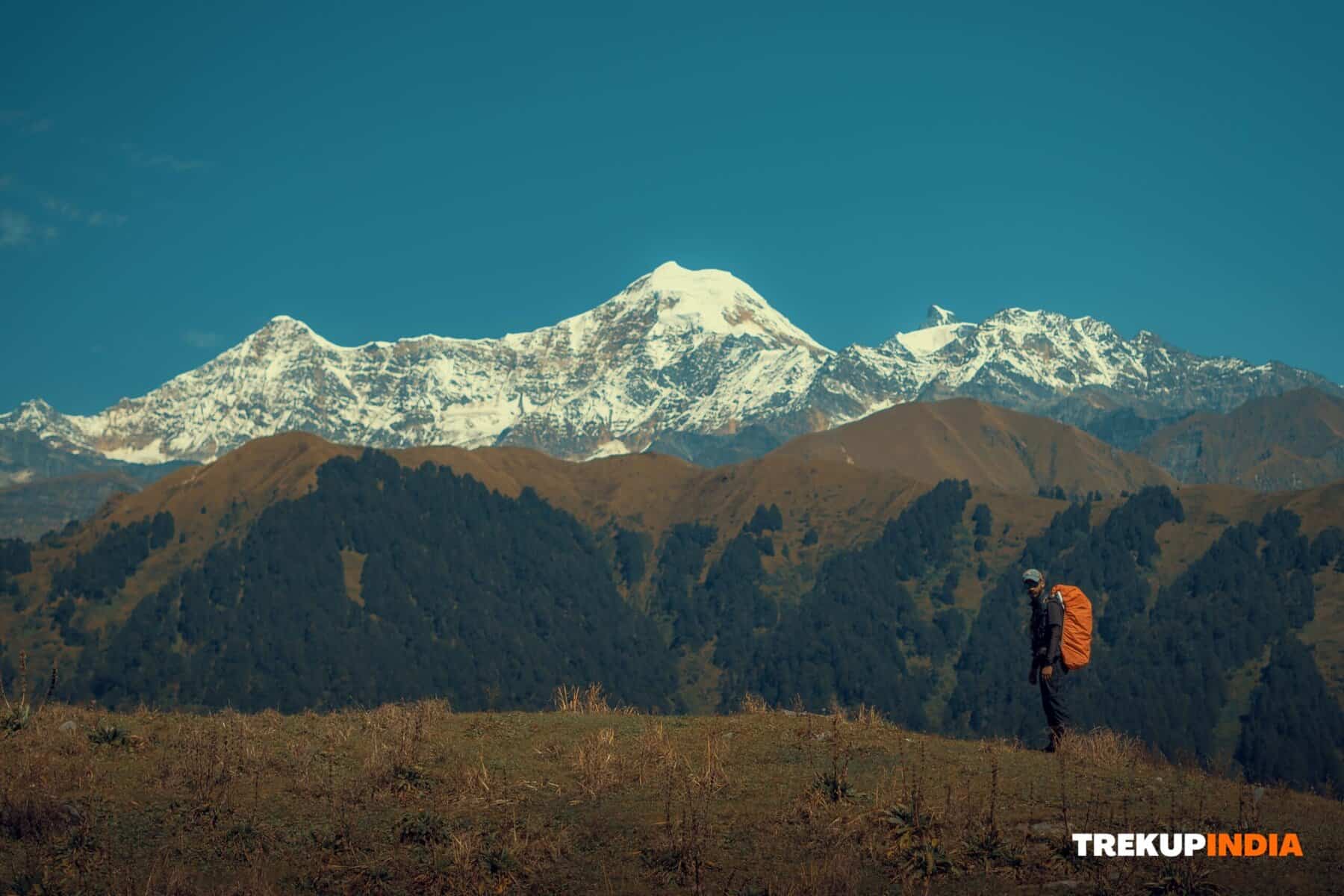
Gangadikal Peak in the Kudremukh ranges of the Western Ghats is among the lowest mountain peaks within its region, remaining unclaimed and undivided for much of its existence. Gangadikal can be seen throughout a trek, starting from its main roadhead and ascending.
Climbing Gangadikal can be both straightforward and difficult. The summit resembles an intimidating slope, making climbing feel like the ultimate journey. Trekkers ascending this ridge are treated to breathtaking views spanning the Kudremukh range that cannot be seen from other summits such as the Kudremukh summit.
Experienced trekkers may have an added treat waiting for them when they spot animals like gaur and deer and birds that live exclusively in the Western Ghats region. Seeing such wildlife could prove truly inspiring! Starting the Gangadikal Trek can be a thrilling and unforgettable journey that will excite those who relish exploring beautiful landscapes in an easygoing trek.
Best Time for Gangadikal Trek
The best time to visit and experiencing the Gangadikal Trek is between the months of September through the beginning of January. The period immediately after the monsoon season transforms the area into an enthralling panorama with vibrant greenery as well as stunning landscapes. What you can be expected round the year:
- Post-Monsoon to Winter ( September – Feburary):
- The scenery will transformed by new vegetation and stunning landscapes.
- Sometimes, dense fog and strong wind create intrigue and excitement on the mountain peaks.
- Summer (April – May):
- The landscape changes to various brown and green hues, offering a unique and stunning landscape.
- The summer months, however, pose the highest danger of forest burning, making trekking more risky.
- Monsoon (June – August):
- The heavy downpours make trails difficult and, in many cases, impossible to navigate.
- In the monsoon season, the degree of difficulty increases dramatically, and forest departments could enforce trekking prohibitions to limit the risk.
To enjoy a secure and safe hike with the best sights, consider a trek in the post-monsoon season.
Highlights of Gangadikal Trek
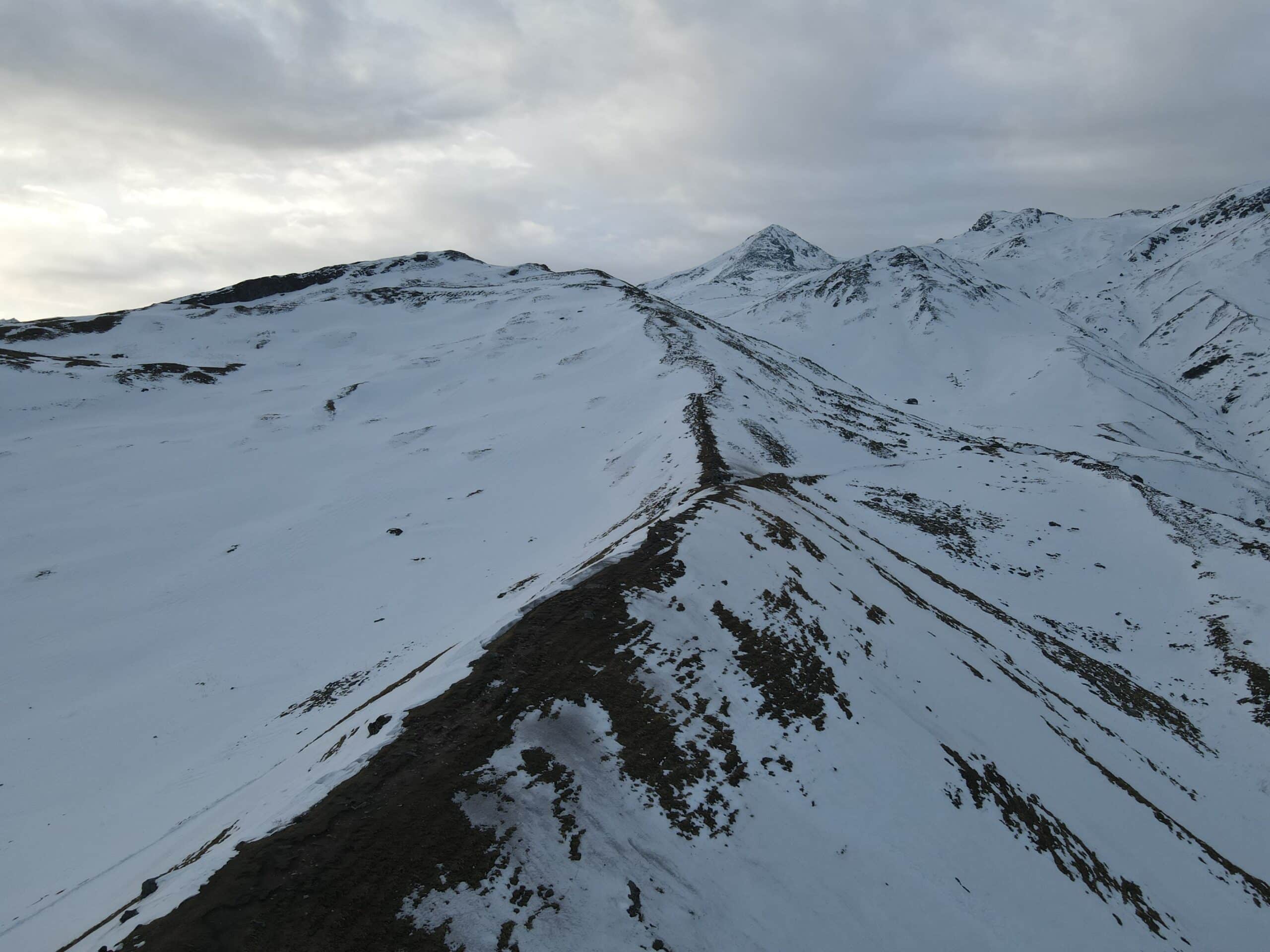
1. Amazing Panoramic Views: With a height of 4,806 feet, Gangadikal Peak offers an unforgettable 360deg panoramic. From the summit, you can look over vast valleys covered in dense shola forest and marvel at the expansive Kudremuka forest. The view extends out to huge grasslands of Shola that appear endless.
2. Key Landmarks and Natural Features
- Kyatanmakki Hills: The prominent hills are visible in the scene.
- Distant Peaks: When clear, you can see the horizon extends into Kurinjal, Valikunja, and Valikunja, bringing an extra dimension to the horizon.
- The Lakhya Dam’s Backwaters: Enjoy the stunning view of the shimmering water.
- Kudremukh Dam: Nearby, the clear waters enhance the beauty of nature in the area.
- Historic Relics: If you’re lucky enough to see the sun shining, you might even see the spooky remains of Kudremukh’s defunct mining town close to Lakhya Dam.
3. Amazing Nature trails
Discover the lush forests of Shola through beautiful trekking trails that wind through lush tropical mountain landscapes. The dense forests and towering trees do not simply shield you from direct sunlight but also give the most enchanting and mysterious atmosphere.
Each element, from the stunning mountains to the subtle features of the water bodies–creates an unforgettable trip at Gangadikal Peak.
4. Wildlife and Natural Beauty:
- Abundant Fauna Be prepared to witness large numbers of gaurs and deer wandering around freely. Birdwatchers are sure to spot species like Grey Hornbills, Malabar Trogons, and Orange Headed Thrushes.
- Reptile Reunions This trail is home to a variety of snakes, including Malabar Pit Vipers and shieldtails.
- Transportation Notes: Although buses run within the vicinity, they’re not reliable for getting you to your destination. Consider alternative transport options if necessary.
Gangadikal Trek Detailed Trail Information
Starting Point & Initial Ascent:
- Beginning Place: The trek begins from the forest post-checkpoint close to the road’s entry point. Parking is provided for at least three vehicles.
- Marked Trail:
- The initial 1.5 kilometers are clearly indicated to be suitable for four-wheel drive vehicles.
- An easy climb of 100 meters takes the visitor into a tropical forest brimming with evergreen, lush trees that are perfect for seeing Malabar huge squirrels.
- Grassland Stretch:
- Follow a gradual slope through the grasslands. After climbing about 200m, Gangadikal Ridge emerges on your left. It offers amazing panoramic views.
- Find a tiny metallic structure in the middle of the ridge. This acts as a key point of reference.
Mid-Trek Landmarks & Viewpoints:
- Woodland Passage:
- The path then ascends another 80m to an area of woodland in which the branches create tunnel-like structures.
- The ascent and descent are strenuous, taking 150m until you get to the Jeep trail section.
- Kurinjal Lookout:
- After a 400-meter ascent to the very first view point, Kurinjal Lookout. The vast flat area has stunning views and Kurinjal on your left–a perfect spot for a quick break.
- Second Viewing Point:
- Follow the trail until you reach an open space that is home to remnants of a former construction by humans. This is where Gangadikal Ridge stretches out before the hikers, with Ajikunja (Valikunja) peaking to the left as well as Kurinjal to the left. The section is about 1-mile of trekking.
Summit Experience:
- Gangadikal Ridge Summit:
- You can zigzag across shola grasslands as well as forest trails until you finally reach the top.
- On the summit, take in the stunning panoramas at Kudremukh, Lakhya Dam’s calm backwaters and Kudremukh city beneath. The grassy carpet ,as well as the soft sounds of the wind ,make for a serene atmosphere.
Descent Guidelines
Planning Your Descent:
- Turn Around Time (TAT):
- Begin your journey before 2 pm so that you return to Kudremukh prior to sunset.
- Descent Details:
- The descent typically takes around two hours.
- From the viewpoint below, the first portion requires additional attention; the uneven surface including the shifting gravel and rock require small, careful movements with your body pointed towards the summit.
- Retracing the Route: Take the exact path to ascend. When you arrive at the last point of view, the descent becomes more simple.
How to Reach For Gangadikal Trek
The trek begins around 33 km from Kalasa, a major city in the Malnad region. Before you begin your trek, you must visit Kudremukh town for the required permits. Hire an expert local guide to assist with the trek.
Important:
- An arrival in Kudremukh: Plan to get to Kudremukh Forest Office Kudremukh Forest Office before 10:00 a.m. to register and for the inspection of trees.
- Price: Treks start at about 500 dollars per head (guide costs are an extra INR 1100, which is approximately. $12 USD).
By Vehicle
From Bangalore to Kalasa:
- Route Overview:
- Take the Chikkamagaluru route until you arrive at Kottigehara.
- In Kottigehara Junction, turn right toward Kalasa.
- Continue to Kal Junction and follow the directions to Balagal and Balagal and Kudremukh’s starting location (the Kal Junction to Balagal route is the most convenient).
- At Kudremukh:
- Show your permit online at your Kudremukh entrance point.
- Once you have crossed the Bhadra River, turn left after the roundabout. You will find the Kudremukh Forest Office, which is located just to the left.
Your guide will assist you on the hike to ensure you arrive at the summit without incident.
Public Transit Options
The public transportation system can be a challenge because there aren’t many bus options:
- Public Buses Get off at Kudremukh and secure entry permits. Consult an expert before taking another bus to get to the main station (approximately 12 miles).
- Taxis You may want to consider hiring a taxi service to get a better service.
- Airport Choice: Mangalore International Airport is about 97km from Mangalore International Airport if you want to fly.
Important Guidelines for the Gangadikal Trek
Permissions and Camping
Obtaining Permission:-
- Application: Submit your online application at Kudremukh National Park Trekbookings and select “Gangadikal Trek.”
- Confirmation A: The confirmation code will be delivered via email to the address you provided. The day before your trip, you must show the confirmation number to the forest office, fill out the form, and present an ID that is valid for the government. (Aadhar card is highly recommended).
Camping:-
- In The Park: Camping is not allowed.
- Alternative: Private homestays in the vicinity of the park have campsites available.
- Prices: Off-season rates typically are between INR 800 to 1200 per night, when during peak hours, prices could rise to INR 1200-2500 per evening.
Stay Options Near Gangadikal Trek
If you would like to sleep in your hotel prior to the hike, there are several hotels accessible close to the forest checkpoint. Examples include:
- Bella Homestay: Run by Chandan situated near close to the Forest Office.
- Reservations: Call 9110684643 to make a reservation for your stay.
Trek Timings
- Start: Treks begin between 6 a.m. and 10 a.m.
- The deadline to summit: Aim to reach the summit before 1 p.m. in order to have sufficient time to get back at the checkpoint before dark comes in.
- Recommendation: Get up early in order to make sure you’re at the Gangadikal base before the evening.
Food and Water on the Trek
- Food:- There is no restaurant during the hike. Food items that are pre-cooked from Kalasa are recommended. Bring the steel containers you have brought with you. Be mindful of the environmental impact by avoiding disposable plastics.
- Water:- Gangadikal is not equipped with its own source of water. You can refill your water bottles at the Kudremukh town Forest Office or the local eatery located in Kalasa.