Dzukou Valley and Japfu Peak Trek
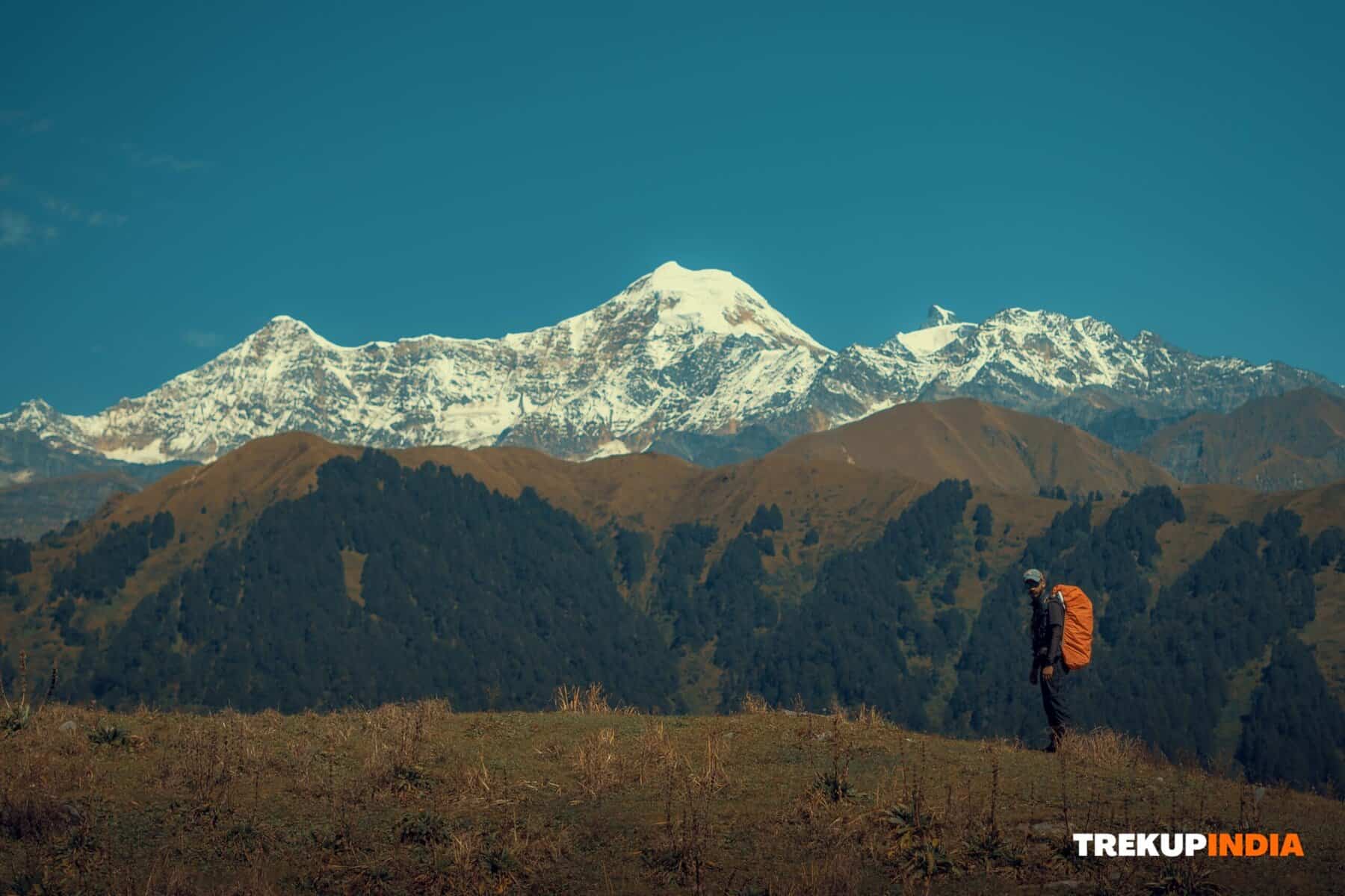
Dzukou Valley in Nagaland is famed for its breathtaking natural beauty. This picturesque spot boasts lush green hills, thick forest, flowing waterways and an array of vivid blooms that line its huge basin and meadows. Dzukou Valley has become a top trekking trail because of its captivating natural splendor; trekrs marvel at its staggering natural splendor as they traverse difficult ascents through thick bamboo forests to reach this idyllic destination that leaves visitors speechless at its breathtaking natural splendor.
It is located between Nagaland in the state of Nagaland and Manipur. The Dzukou Valley is a breathtaking paradise of natural beauty with rolling hills of vivid lush, green forests twisting rivers, and an array of vivid blooms that cover the vast valley with lush meadows. It is referred to as the “North-East’s Valley of Flowers” This beautiful spot is located in a height of 2438m above sea and is located just below Nagaland’s Japfu Peak. From a distance it appears as if the valley looks like polished grass that is fed by the gentle flow of the Dzukou as well as the Japfu rivers. They can get frozen during the winter months. The valley flooring is made up of a mix of vibrant plants made up of aconitum, lilies the rhododendrons, and euphorbia in all shades, that are so abundant that they completely cover the valley and are hidden from view.
Scenery indicates that the valley lies at the center of an expansive, ancient volcanic crater which has long since gone dormant and inactive. From its edge you can look down upon the valley below which becomes particularly evident at an altitude of 2400 meters where dawn and sunset shadows cast their spell of mysterious beauty.
At the head of a valley lies a large mountain lodge resembling a rustic outbuilding, nestled amidst oaks and rhododendrons that form an outgrowing. A nearby group of oaks and rhododendrons create a miniature forest, while further steep slopes offer stunning vistas as one climbs upward. The Trails quickly diminish once one ascends further; adventure awaits those willing to brave dense bamboo forests on their journey uphill!
Here, individual trekkers and adventurers alike can hone their treking skills and gain invaluable experience.
Best Time for Dzukou Valley and Japfu Peak Trek
To have the most fun and secure trekking trip, you should plan your hike in the months of October and April. Here’s why:
- Best Weather Conditions: The time is characterized by clear skies, moderate temperatures, and less chance of heavy rainstorms. These conditions ensure that trails remain dry and stable.
- Scenic Beauty: Autumn (Late September to October): Enjoy beautiful trekking conditions when blooming wildflowers fill the valley floor, along with lush greenery providing an inspiring trekking backdrop. Spring (March through early April): Benefit from gorgeous floral displays as you trek in cool, fresh air conditions that add another element to the adventure!
- Beware of Monsoon Risks: The monsoon period (June through September) usually brings torrential rain that can result in slippery trails and a higher chance of Landslides. The conditions could seriously affect security as well as trail accessibility.
Best Time for Dzukou Valley and Japfu Peak Trek Detailed Trek Itinerary Day Wise
Begin a journey that will be unforgettable across Nagaland’s beautiful scenery and rugged terrain. The detailed route outlines an extensive trek from Kohima towards Japfu Peak, complete with crucial details about the routes, travel tips, and practical tips.
Day 1: Arrival at Kohima
- Kohima, situated about 80km from Dimapur Kohima, is the start point of the Dzukou Valley trek.
- Transport Options: From Dimapur, rail and air connections are accessible to Dimapur.
- Taxis (shared or private), as well as buses, link Dimapur to Kohima.
- Additional Information: See section “Getting There” section for further information about transportation.
Day 2: Kohima to Dzukou Trekkers’ Hut
- Elevation: 8,045 feet
- Distance & Duration: 9km covered in about 6 hours
- Terrain: Combination of gentle upward climbs and steep inclines.
- Water taps can be seen at about 3km in the hike.
- Route Information: Early Start: Depart from Kohima through NH 39 and head towards Zakhama Check Post (approximately 15 km by automobile).
- The shared cab rate is about INR 80. Private taxis start at INR 500.
- Check Post and Beyond: At North Kohima Students Union, you can pay an INR 80 for the cleaning services in the local area.
- Take a trip to the source of water that runs through all year round (though it is not suitable to drink) on the route made for jeeps. You will go through bamboo and deodar forests.
- Steep Ascent: Turn left and follow the stream for approximately 1 km. Then, continue along the bank on your left until you get to a public water refill shelter located in the area referred to by the name of Crying Child Valley.
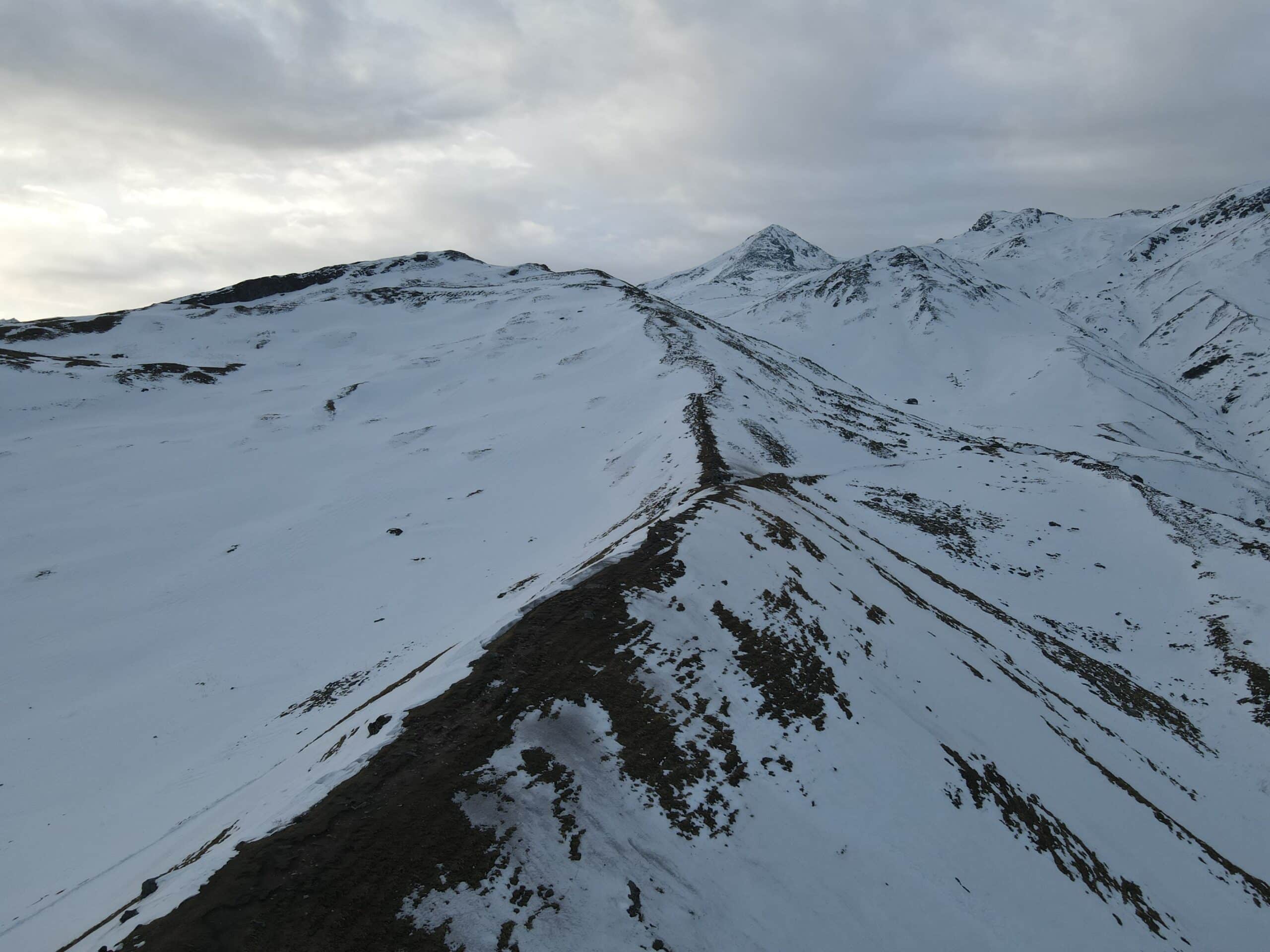
- The Final Mile: The last 5 km will take you to an unnamed pass that is 2,550m with spectacular panoramas across Dzukou Valley.
- After a quick trek through an eucalyptus forest and a 200-m part of the ridge with a fork on the trail and a left-hand way downwards.
- The arrival at Dzukou Trekkers Hut: Option to share a space: INR 100 per person, per night.
- Private beds/bedrooms: INR 300 per bedroom
- Additional Amenities: Meals at a basic price (with modest prices) as well as limited snack choices
- Reminder: Reservations are available on a first-come-first-served basis.
Day 3: Exploring Dzukou Valley (Optional)
- Stay: Overnight at Dzukou Trekkers’ Hut
- Activities: Take an easy 15 minutes walk to visit The Ghost Caves (locally known as Bhoot Gufa).
- TIP: Bring an additional torch since the cave is over a Kilometer.
- If you’re feeling adventurous, ascend from the hut and into the huge caldera. Here, the monsoon’s blooming meadows and huge meadows make for a stunning scene.
Day 4: Dzukou Valley to Viswema Village
- Elevation Variation: From 8,045 feet to 5,351 feet
- Distance & Duration: About 25km over 7 hours
- Terrain: Predominantly downhill with moderate difficulty.
- The water sources are readily available around halfway through the trek the trek, which makes it simple to fill up bottles on the the Trekkers’ Hut just before the hike begins.
- Route Highlights: Follow a fairly easy and smooth trail across the left-hand edge of valley ridges. It will wind between thin bamboo thickets.
- Take several turns and switchbacks before reaching an incline with stunning panoramic views from Imphal Highway and Viswema Village.
- Proceed downhill to the water pipe that connects Viswema Village, allowing you to refill your water prior to the last descent.
- The trail ends with Trekkers’ Point near the top of the hill.
- If no transportation arrangements are made, A smooth, 9-km road is a good way to connect Viswema Village with NH 61 through the Viswema Community Hall, where free meals, stays as well as water taps are readily available.
Day 5: Viswema Village to Japfu Peak Base
- Elevation: 6,600 feet above sea level
- Distance & Duration: 10 km over 5-6 hours
- Trail Difficulty: Moderate uphill
- Water Advisory: Carry At least Liters of water from Viswema in Viswema. Water availability is very limited.
- Route Description: Begin by traveling north-west for 3 km along a main road used by locals.
- Forest Ascent: Transform onto the moderately difficult but comfortable road that winds through the thick forest.
- Highlights: Relax and enjoy the peaceful sounds of music from birds. This is a great book for bird watchers and photographer enthusiasts.
- Campsite at Rhod: The trail rises on a gentle line of ridge until you arrive at the clearly-marked campsite, dubbed “Japfu Peak,” where large open spaces and a source of water allow for overnight camping.
Day 6: Japfu Base Camp to Japfu Peak and Return
- The summit is about 3,100 feet away from the base camp of about 6600 feet.
- A 6-kilometer round-trip travel time of 6 km, requiring approximately six hours.
- Moderate difficulty trail, including numerous uphill portions can be challenging.
- Water: Take a minimum of two Liters starting from Viswema to Viswema. Water is in short supply along the road.
- Early Sunrise for Sunrise: To get the most stunning sunrise views from the top Leave the campsite by 2 am.
- Route Highlights: A well-marked trail which begins in dense forest with few views. It then rises over the tree line for around 150m, before reaching Japfu Peak.
- Panoramic views: From the summit, you can enjoy panoramic views of valleys, mountains, and villages throughout Nagaland, including views of areas located in Arunachal Pradesh and cities such as Dibrugarh in Assam.
- Return: Retrace your steps towards Viswema Village, then continue toward Kohima.
How to Reach & Plan Your Travel to Nagaland
Dimapur is Nagaland’s entry point and the regional economic and development central point. It’s the only city within Nagaland with railway and air connectivity, making it an ideal access point for travelers from Manipur.
Connectivity in Dimapur
- Rail – Its Dimapur railway station has a good connection with major Indian cities like Guwahati, Kolkata, New Delhi, Bangalore, Chandigarh, Amritsar, Dibrugarh, and Chennai.
- Air-Dimapur Airport is the only civilian airport that offers flights that connect Kolkata, Delhi, Dibrugarh, and Chennai.
- Travel Tips:
- Book: When travelling to Delhi or Bangalore, be prepared for higher rates due to services that are not as extensive.
- Overnight Stops: The flights from Kolkata and Dimapur may require a night-time layover. If you arrive in Dimapur in the evening is recommended to get the best connections.
The journey takes you between Dimapur to Kohima
- Distance – Kohima can be found located approximately 80 kilometers away from Dimapur.
- Transportation Options:
- Private Taxis One way, around 1,500 rupees. way.
- Taxis shared: Around INR 150 per person from the railway station or airport.
- Buses: The cost is around INR75 for each person. The travel time varies from 5 to 6 hours.
Accommodation in Kohima
Kohima provides a range of accommodation options that will suit the needs of different budgets.
- Hotel Budget: About INR1,200 per room.
- Homestays/Guesthouses: Around INR 700 per night.
This guide will help you confidently organise your trip to ensure smooth travel between Dimapur through Kohima and beyond.
Important Pre-Travel Information
- Inner Line Permit:
- A must for travelling in Nagaland.
- Obtainable At Nagaland Houses in Kolkata, Guwahati in Guwahati, Kolkata or Dimapur.
- Permit Fees: INR 40 to get the permit
- Rs 30 per individual cost of entry to Dzukou Valley (paid upon receiving the permission).
- General Tips:
- Make sure you’ve got enough water, in particular for areas with restricted access.
- Use solid trekking shoes and bring trekking poles to avoid the most slippery or steep sections.
- Track weather conditions because trails may be difficult in monsoon and post-monsoon season.