
Gwaru Pass Trek
Gwaru Pass Trek
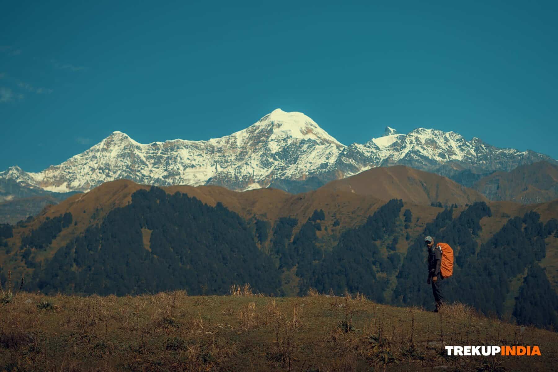
Situated within Kullu Valley in Himachal Pradesh, the Gwaru Pass trek provides breathtaking panoramic views and unforgettable experiences at high altitudes. From Chikka in Chikka, an attractive trail leads through Deo Tibba base camp Seri and over to Gwaru Pass, which towers at 4,790 feet before leading down into Malana village within Parvati Valley.
Highlights and Challenges, Scannable Diversity-Enjoy dramatic river traversals, glacier crossings, and expansive views of legendary mountains like Mt. Deo Tibba and Indrasan!
Natural Beauty Uncover meandering streams with lush grasslands, scenic camping spots, and breathtaking glaciers that dot your path.
Crossing Gwaru Pass can be challenging, necessitating extensive trekking experience and the ability to navigate unmarked routes with steep ascents and descents.
Gwaru Pass Provides an Unexplored and Dual Pass Experience
While Kullu Valley’s natural splendor enthralls visitors, many remain unfamiliar with Gwaru Pass as one of its least explored routes. Not only can one travel over Gwaru Pass; Tentu Pass can also be included for an unforgettable dual pass experience that showcases some of Kullu Valley’s most stunning and picturesque natural scenes.
The trail’s highlights will be plentiful and varied over the course of seven days. Passing through broad valleys and sparkling rivers will ultimately lead you to Chandratal Lake; its round shape, illuminated by early morning sunlight, creates an incredible sight against the Pir Panjal range’s towering mountains.
To ensure optimal safety and conditions, it is advised that Gwaru Pass trekkers undertake it during times of optimal conditions and safety. This makes for a much smoother trek and safe travel over treacherous terrain. This not only guarantees an easier trek experience but also guarantees safe passage over such challenging terrain.
Start exploring Gwaru Pass as you discover its unexplored beauty in one of the world’s most breathtaking regions! Don’t let this challenge pass you by; discover why so many people consider this uncharted territory an undiscovered treasure in one of Earth’s most stunning regions.
Gwaru Pass Trek Highlights
- This rock formation stands out and serves as a recognizable landmark to guide you to the trek’s starting point. Upon approaching it, you’ll realize that this charming rock face is, in fact, a massive boulder with an imposing overhang.
- Upon reaching the summit of Kunagalu hill, a breathtaking vista unfolds, revealing the town’s expansive countryside. The scene encompasses a multitude of hills, coconut plantations, farmlands, and the meandering Arkavathi River passing through various villages. The juxtaposition of these elements creates a sense of being in a lush tropical oasis.
- While the trek is short, there are a few parts where you must pass through caves, jump on rocks and large stones, and navigate carefully through open areas. These parts are exciting but safe. Be cautious when encountering them, particularly if older individuals and children accompany you.
Who Is the Gwaru Pass Trek Meant For?
It is Gwaru Pass Trek is designed to attract travelers who are willing to tackle a demanding seven-day trek through varied and rough terrain. The trek is best to those who
Maintain high physical fitness: The trek involves difficult ascents and descents as well as unmarked trails and different terrains, from meadows of grass and river crossings, to mountain passes as well as moraine glaciers. There are also areas covered in snow. The need for a high degree of endurance and agility is required.
Are you a previous hiker:
Familiarity with conditions at high altitude and the ability to navigate treacherous, uncharted trails will allow you to manage the physical as well as the technical elements of the trek better.are committed to preparing:
Tailoring your workout routine is essential. Integrate activities such as climbing stairways to increase endurance with agility and strength training in order to be ready for challenging mountain hills and rough terrain.
If you’re a seasoned trekker who has a strong physical condition and the determination to train for a difficult but rewarding trek The Gwaru Pass Trek offers an thrilling opportunity to discover the Himachal Pradesh’s most elusive jewels.
Gwaru Pass Trek Detailed Itinerary
Day 1: Take a drive to Chandigarh to Manali
Route & Distance:
- The Total Distance is About 310km.
- Beginning Elevation: 1,053 feet (remains constant upon departure).
Overview:
Manali which is situated in northern Kullu Valley, is known for its tranquil setting in beautiful apple orchards and high mountains covered in snow. It is also the point of departure for Gwaru Pass Trek, Manali is a perfect starting point. Gwaru Pass Trek, Manali provides a variety of accommodation that can be adapted to any budget. It can be ideal for getting acclimated.Travel Tips:
- by road: Options include private taxis and busses (operated through Himachal Roadways Transport Corporation).
- Time of Arrival: Aim to reach Manali around 4-5 pm so that you have plenty of time to settle in and to prepare ahead for the trek ahead.
- NOTE: Roads around Swarghat are often bumpy and rough because of potholes.
Day 2: drive to Manali to Barahazar Day 2: Drive from Manali to Barahazar Trek through Barahazar to Chikka
Manali to Barahazar:
- Distance: 18 km
- elevation gain About 2,600 feet (rising from approximately 6,725 ft to 9,325 feet).
- Transport: The public transport system is very limited. It is recommended to rent an auto rental with a driver who is private (estimated at around $2200).
Trekking starting from Barahazar up to Chikka:
- Distance and Duration: Around 2.5 kilometers with an easy climb from 9,325 feet to 10,154 ft. Expect an approximately 2.5-3 hour climb.
- Terrain Its trail winds through meadows of grass, rocks as well as steep stony slopes.
- Highlights:
- Perspectives over the Dhuongon River as well as the rough Gwaru Pass trailhead along its left bank.
- An attractive 15-minute walk through the forest that includes rocky outcrops as well as grasslands that are open.
- Beautiful bridges and railings offering beautiful views of powerful flowing rivers.
- Facilities: Along the way there are two temples as well as the huts in Takshak Nag, where a design of a snake on a stone gives a distinctive touch.
- Tips: Ensure your water bottles are stocked with safe source water from the river before you settle in to sleep for the evening.
Day 3: Trekking to Chikka to Seri
Distance & Duration:
- Around 6.9 kilometers over the course of a six-hour trek.
Elevation:
- The ascent is from 10,154 feet to an estimated 12,780 feet at Seri.
Route Details:
- You can traverse through grasslands that are open as well as forest trails and rocky sections that are steep.
- Rest Stops:
- The climb takes approximately 1.5 an hour out of Ocheri until you reach the Chorgan campsite (at around 12,355 feet) which is a great place to have lunch.
- After lunch, you can continue for another 30 minutes and take in the vast valley that offers stunning perspectives from Deo Tibba, Norbu, and Bansi mountains. It also includes the Dhuongon River cascading from Tentu Pass.
- Tips: Early morning starts with a pre-packaged lunch to keep your energy up during this long, strenuous and tiring day.
Day 4: Trekking through Seri to Chandratal and back to Seri
Distance & Duration:
- Total Distance: 12 km
- Time: Approximately 7 hours.
Elevation:
- The range fluctuates between 12,578 feet between 12,578 and 15.122 feet.
Itinerary Highlights:
- Morning Ascent:
- A hike starting from Seri up to Tentu Pass (13,408 ft) for approximately 1.5 hour. Take in the stunning orange-reddish tapelands, and then take time at the top to enjoy the views.
- Midday Trek:
- The deep knees of the Dhuongon River tributary, then go on towards Deo Tibba Advance Base Camp (around 13,980 feet) by walking for 30 minutes.
- Begin to tackle a long 2.4 km ascent over difficult terrain, leading you up to Chota Chandratal, where an epitaph pays tribute to the Shri Vilas G. Deshpande, for his part as a participant in The Deo Tibba Expedition.
- Chandratal Lake Visit:
- A short walk of 10 minutes through a pond at high altitude brings you to Chandratal lake, a shapely freshwater gem that stretches for 2.8 kilometers. The lake’s varied hues and serene ambience make it a great spot to eat lunch.
- Return:
- After an afternoon of rejuvenation by the water, trek back to Seri and retrace your steps prior to returning to the camp site.
- Morning Ascent:
Day 5: Trekking From Seri towards Gwaru Thach
Distance & Duration:
- Distance: Approximately 2.8 km
- Elevation Gain: Around 515 ft
- Time: Roughly 3 hours.
Highlights:
- Explore the riverbanks of Gwaru Nala, experiencing a mixture of lush grasslands rocks, and occasional snowfields.
- Explore the ever-changing terrain with stunning mountain views at Gwaru Thach. Gwaru Thach campsite–an ideal resting location before the harder ascents to come.
Day 6: Trekking starting from Gwaru Thach to Bareh via Gwaru Pass
Distance & Duration:
- Total Distance: Approximately 8 km
- Time: Full-day trek with several different stages.
Elevation Details:
- Start in Gwaru Thach (~13,093 ft) before ascending through Gwaru Pass (~15,882 ft) before dropping down to Bareh (~13,549 feet).
Highlights & Challenges:
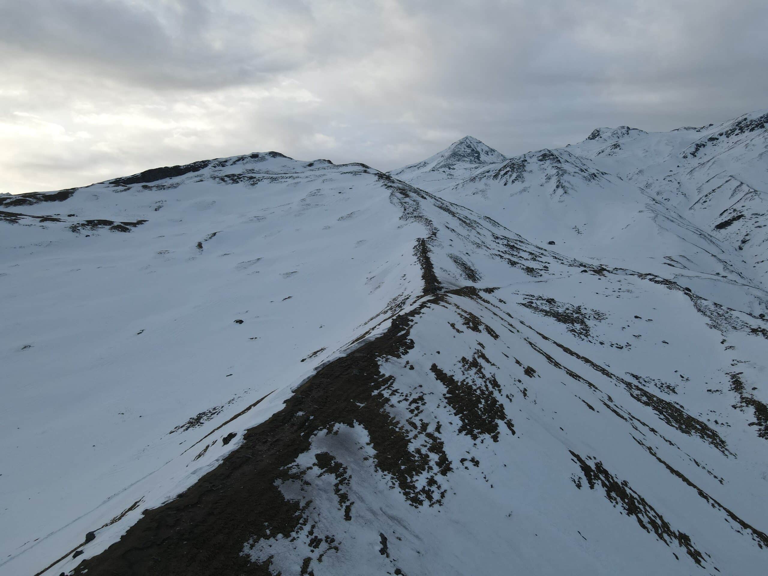
- Early morning: Start with a gradual climb through a moraine-covered landscape and is where careful navigation becomes crucial as the terrain is slick with ice glaciers, and rock Ridges.
- Gwaru Pass:
- Following around 1.5 hours of walking to the south and southward, the trail will lead to Gwaru Pass, which is one of the most stunning mountain passes within the region. It offers amazing views of mountain peaks like Deo Tibba, Norbu, Bansi and Aliratni.
- Descent:
- The river is a serpentine Malana Nala River downstream through the boulder-debrisped area until you reach an idyllic lake.
- The unmarked descent demands cautious route selection. Allow about three hours in order to arrive at Bareh. Bareh.
- Evening:
- Make camp in Bareh to take in the breathtaking views. Nearby, the Gerwa Kothi peak is revered by the locals, and provides an extra dimension of spirituality to your experience.
Day 7: Trekking to Bareh to Malana
Distance & Duration:
- Distance: Approximately 7 km
- Time: Around 5 hours.
Elevation Change:
- The descent is from 13,549 feet up to 9,006 ft which is a substantial decrease of more than 3,500 feet.
Route & Highlights:
- The trek will take you through thick forest, sprawling grasslands and charming villages.
- After leaving Bareh to the south, you should make a stop at Bukhare Campground (at 11,771 feet) with a temple as well as shepherd’s homes are the markers for the route.
- Continue on to Ringer Rhar (around 11,161 ft) Then cross the river, before continuing on marked trails through the woods.
- Final Destination:
- You will arrive at Malana well-known by the name of “Little Greece.”
- The city is renowned for its old traditional democratic practices and distinctive traditional practices of culture, Malana offers excellent camping locations or accommodation in the local area to enjoy a relaxing rest.
- Cultural Note:
- Local customs must be respected as well as the stringent rules established by the village council. Photography is permitted, but keep in mind personal property rights and the local sensibilities.
Day 8: Take a drive to Malana to Kullu
- Route & Options:
- Distance Malana can be found approximately 45 km away from Kullu.
- Transport:
- Bus services that are regular and reliable are readily available but be aware that they typically only run up to 8:30 am.
- Alternately taking a taxi with a driver is advised. The journey should take about 3 hours.
- Accessibility:
- If you are arriving by foot to Malana the short 30 minute stroll may be required to get to a location for pick-up.
The comprehensive guidebook provides an easy-to-follow day-to-day itinerary for Gwaru Pass. Gwaru Pass Trek, ensuring that you are well-equipped for a difficult but unforgettable journey traversing the breathtaking scenery in Kullu Valley. Be safe, enjoy the trek, remain secure, and take a dive in the incredible nature and fascinating culture along the journey!
How to Reach Chandighar and Manali?
Reaching Chandigarh
Through Air: Chandigarh International Airport provides convenient air access for travelling across India. Regular domestic flights make this an attractive option for visitors.
By Train: Chandigarh Railway Station is well connected with other cities via The Indian Railways network, offering frequent train service.
By Road: Chandigarh can be reached easily by auto or bus. Expressways and highways connecting neighboring cities such as Delhi provide for comfortable driving experiences.
Reaching Manali
By Road: Manali can be reached easily via roads. Approximately 300-350 kilometers separate Chandigarh from Manali.
Bus Service: Himachal Roadways and private operators offer bus service from Chandigarh (and Delhi) to Manali.
Private Taxis and Self-Drive: Renting or driving your own vehicle is an incredible experience that provides scenic routes through the hillsides.
Travel time: The journey typically lasts between 7-8 hours depending on road condition and traffic levels, as well as any special considerations such as monsoon season or heavy snowfall in winter.
Key Tips- Seasonal Considerations: Road conditions can differ drastically during monsoons or heavy snowfall.
Take in stunning sights along your route for an unforgettable journey experience. This will make sure that it remains one of the highlights of your trip.
Chandigarh and Manali are conveniently interconnected cities, providing you with multiple transportation options that best meet your needs and preferences. Take your time exploring these breathtaking locations!


Want To Trek Like Pro?
Check out the following videos if you want to trek like a pro trekker and improve your skills. These videos contain helpful tips, tricks, and techniques to help you trek like a pro. Whether you’re a beginner or an experienced trekker, these videos can provide valuable insights to enhance your trekking experience. So, watch the videos below by Trekup India experts to take your trekking skills to the next level.


Know Everything About Acute Mountain Sickness
Acute Mountain Sickness is a medical condition that can occur when individuals travel to high altitudes, typically above 8,000 feet. It is caused by the decrease in air pressure and oxygen levels in the air as altitude increases. Symptoms of Acute Mountain Sickness may include headache, nausea, vomiting, dizziness, and difficulty sleeping. To avoid Acute Mountain Sickness, it is important to gradually adjust to high altitudes and seek medical attention if symptoms worsen. To learn more about this condition, check out the videos by Trekup India.


